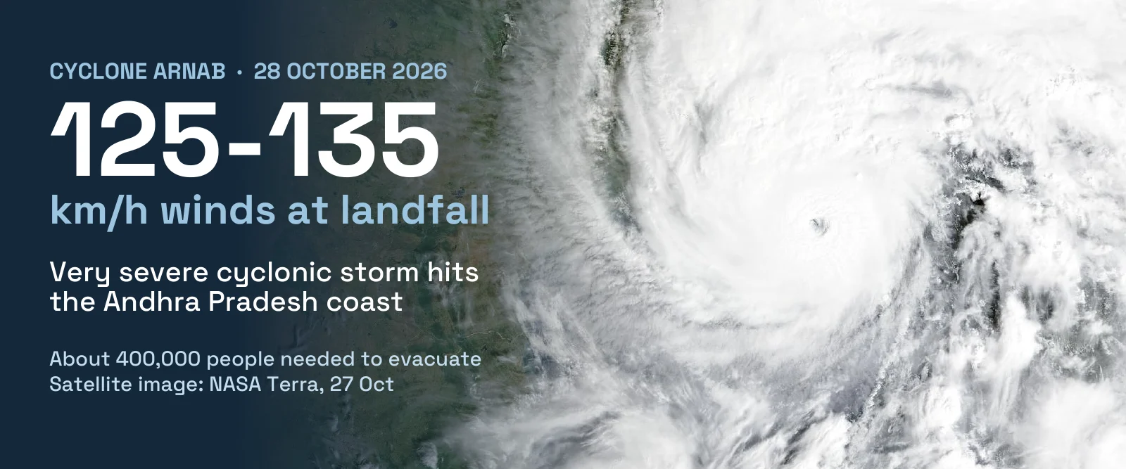
Cyclone Arnab is a very severe cyclonic storm that made landfall on the Andhra Pradesh coast, near Narsapur in West Godavari district, in the early hours of Wednesday 28 October 2026. The India Meteorological Department (IMD) reported a peak of 135 km/h with gusts up to 150 km/h as it crossed, and at least two people have died, both from electrocution (the national disaster response force puts the toll at three). Arnab is the first named cyclone of the 2026 North Indian Ocean season. It weakened to a severe cyclonic storm by late morning, but IMD forecasts very heavy rain in south Odisha on 29 October.
Last updated: 28 October 2026, based on reports published up to about 13:30 IST. This is a developing event and every figure below is preliminary. Wind and rain data come from IMD; casualty and response figures come from Indian officials, the National Disaster Response Force (NDRF), Reuters, AFP, PTI and Indian news outlets.
Cyclone Arnab at a Glance
| What | A very severe cyclonic storm (IMD scale) from the Bay of Bengal, named by IMD on 26 October |
| Landfall | Began at about 01:20–01:30 IST on 28 October and finished in the late morning, about 20 km east-northeast of Narsapur (Narasapuram) and 40 km south-west of Yanam, between Bapatla and Visakhapatnam |
| Winds at landfall | 115–125 km/h at 05:30 IST, 125–135 km/h at 08:30 IST, and a peak of 135 km/h with gusts to 150 km/h (IMD). The pre-landfall forecast was 115–125 km/h, gusts to 140 km/h |
| Rain | 216.9 mm at Visakhapatnam in the 21 hours to 05:30 IST (IMD); 147.5 mm at Kalingapatnam; 118.4 mm at Kakinada |
| Storm surge | IMD forecast 1–1.5 m above the normal tide in low-lying Andhra Pradesh; one live report cites 1.5–2.5 m over Kakinada and Yanam |
| Deaths | At least 2, both electrocutions from live wires in Andhra Pradesh; the NDRF said 3 at 13:23 IST. Odisha reported no serious impact |
| Evacuations | More than 180,000 in Andhra Pradesh and Odisha combined (Reuters); about 57,000 in Andhra Pradesh relief camps (PTI). Odisha figures range from 30,000 to about 100,000 |
| Transport | Operations suspended at three Andhra Pradesh airports (Visakhapatnam, Vijayawada, Rajahmundry); 16 Chennai flights cancelled; at least 12 trains cancelled in eastern India and services on 53 routes suspended |
| Warnings | IMD red message for the Andhra Pradesh and adjoining south Odisha coasts, and a red warning for six south Odisha districts; fishermen told to stay off the sea until 29 October |
| What next | Weakening to 50–60 km/h by evening, and the NDRF expects a deep depression by then; very heavy rain in Odisha on 29 October and heavy rain in parts of West Bengal until 31 October |
Where Did Cyclone Arnab Make Landfall?
Landfall began at about 01:20 IST on Wednesday (an Odisha minister gave 01:30), on the Godavari delta coast of West Godavari district. IMD had forecast a crossing between Bapatla and Visakhapatnam, and Arnab came ashore inside that stretch. IMD placed the crossing point near 16.45°N, 81.9°E, about 20 km east-northeast of Narsapur (also spelt Narasapuram), 40 km south-west of Yanam and 60 km south-west of Kakinada.
Early reports disagreed on when the crossing ended: ANI said landfall was complete by about 08:00 IST, while at 09:38 IST IMD still expected it to continue for about two more hours. Live reports put the end of the crossing at about 10:40 IST, when Arnab moved fully over land and weakened to a severe cyclonic storm, with a peak of 135 km/h and gusts of 150 km/h. IMD may revise these times in its final report.
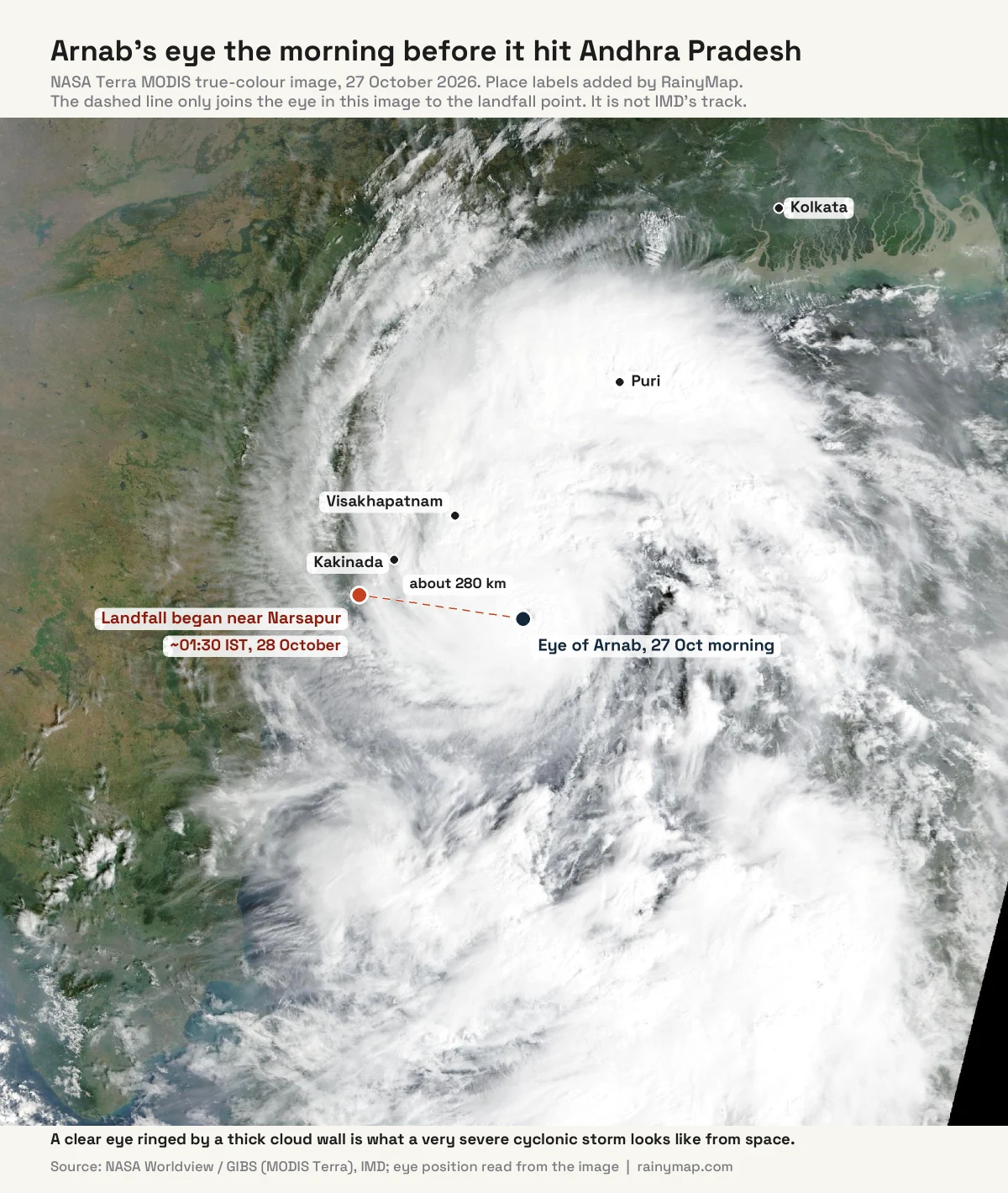
This is almost exactly the stretch that Cyclone Montha hit a year earlier. Montha crossed the coast near Narasapuram around midnight on 28–29 October 2025, as a weaker severe cyclonic storm. For a live view of the rain bands, use our Kakinada radar and Visakhapatnam radar pages.
How Strong Is Cyclone Arnab?
IMD classes Arnab as a very severe cyclonic storm, the fifth of the seven classes on its scale. IMD measures the 3-minute average of sustained wind, which gives lower numbers than the 1-minute average used by the US National Hurricane Center, so the two scales cannot be compared directly.
| IMD category | Sustained wind (3-minute) |
|---|---|
| Depression | 31–50 km/h |
| Deep depression | 51–62 km/h |
| Cyclonic storm (gets a name) | 63–88 km/h |
| Severe cyclonic storm | 89–117 km/h |
| Very severe cyclonic storm (Arnab at landfall) | 118–165 km/h |
| Extremely severe cyclonic storm | 166–220 km/h |
| Super cyclonic storm | 221 km/h or more |
IMD put Arnab’s sustained winds at 115–125 km/h (gusts to 140 km/h) at 05:30 IST and 125–135 km/h (gusts to 150 km/h) at 08:30 IST, with a peak of 135 km/h as it crossed. That is slightly above the 115–125 km/h IMD forecast before landfall. Wikipedia’s running summary of IMD data lists a peak of 155 km/h and a minimum pressure of 973 hPa while the storm was at sea; we could not confirm those two figures in an IMD bulletin, so treat them as provisional.
How did Cyclone Arnab form?
| Date | What happened |
|---|---|
| 24 October | A low-pressure area over the Bay of Bengal becomes a depression in the evening, about 820 km east-southeast of Visakhapatnam |
| 25 October | Upgraded to a deep depression; IMD forecasts a very severe storm and a landfall on 28 October |
| 26 October | Becomes a cyclonic storm and is named Arnab; about 12 hours later it is a severe cyclonic storm |
| 27 October | Very severe cyclonic storm, centred about 260 km south-east of Visakhapatnam; evacuations under way |
| 28 October | Landfall begins near Narsapur at about 01:30 IST; weakens during the day |
What does the name Arnab mean?
Arnab means “ocean” or “sea” in Bengali (IMD gives the pronunciation as “Ornab”). Bangladesh proposed the name for the list the North Indian Ocean countries adopted in April 2020. IMD only assigns a name once a system reaches cyclonic-storm strength (63 km/h or more), which happened on 26 October. Arnab is the only named storm of the 2026 season so far.
How Much Rain Has Cyclone Arnab Brought?
The heaviest rain fell north of the landfall point. Visakhapatnam recorded 216.9 mm in the 21 hours from 08:30 on Tuesday to 05:30 on Wednesday, which is above IMD’s “extremely heavy” threshold of 204.5 mm in 24 hours. Kalingapatnam had 147.5 mm, Tuni 123.3 mm and Kakinada 118.4 mm, all in IMD’s “very heavy” class (115.6–204.4 mm). Narsapur, where landfall began, had only 48.6 mm by 05:30 and Ongole just 0.4 mm. A summary of IMD’s bulletins also reports up to 263 mm in 24 hours in the Anakapalli, Visakhapatnam and Vizianagaram districts. In Odisha, Chandbali and Dhamnagar recorded more than 50 mm.
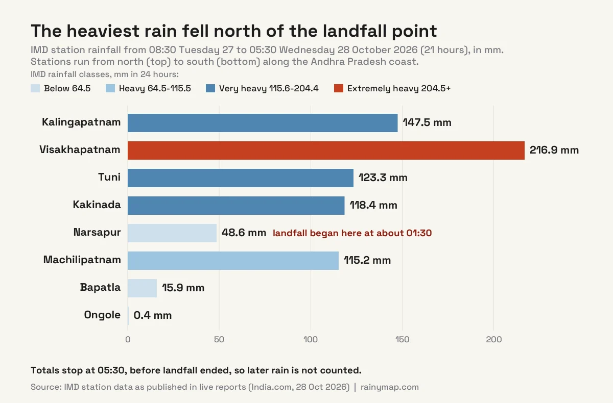
These are early station totals and will rise as the 24-hour accounting closes. For scale, our explainer on how much rain is a lot shows what hundreds of millimetres mean on the ground. IMD’s own warning for 28 October was for extremely heavy rain (21 cm or more) at isolated places in coastal Andhra Pradesh, south Odisha and south Chhattisgarh.
What Damage Has Cyclone Arnab Caused?
Andhra Pradesh: evacuations, electrocutions and damaged homes
Andhra Pradesh’s disaster management authority said more than 12 million people live along the storm’s projected path, and about 400,000 needed to be evacuated. By Monday night nearly 50,000 had been moved to shelters, according to Reuters; PTI later reported about 57,000 in relief camps, and Reuters put the total for Andhra Pradesh and Odisha together at more than 180,000. The state had 10 National Disaster Response Force (NDRF) and 11 State Disaster Response Force (SDRF) teams ready, and the NDRF said 39 teams were deployed across seven states and territories. Chief Minister N. Chandrababu Naidu ordered roads cleared within two hours, and 609 schools were turned into rehabilitation centres.
Damage so far is mostly to trees, power lines and low-lying land. The NDRF counted 31 damaged houses in Andhra Pradesh. Uprooted trees and electric poles caused power cuts and blocked roads, low-lying areas flooded, and Kakinada was under water in places. A Kakinada resident told ANI his house was damaged and he had nothing left but the clothes he was wearing. We found no official figure yet for power outages, crop loss or homes destroyed.
Deaths: two confirmed, three per the NDRF
Two deaths in Andhra Pradesh are reported with details, both from electrocution. A 53-year-old man died on Tuesday night after touching a live wire that had snapped over a field channel, and a woman died on Wednesday morning after stepping on an exposed live wire outside her home in Yellamanchili, Anakapalli district. At 13:23 IST the NDRF said three people had been killed in Andhra Pradesh and 31 houses damaged, without saying who the third person was. Earlier, at 08:45 IST, the chief minister had said no deaths were reported, and early Reuters and AFP reports also said none, so the toll has risen during the day. Wikipedia’s tally lists a woman killed by a falling tree in Puri, Odisha, which we have not seen confirmed in other reports; the NDRF said Odisha reported no serious impact. Expect the toll to change.
Odisha, Jharkhand and West Bengal
Odisha moved between about 30,000 and 100,000 people to safer places, depending on the report, closed schools in 16 of its 30 districts and kept 2,037 cyclone shelters ready. IMD’s Bhubaneswar office issued a red warning for six southern districts (Ganjam, Gajapati, Rayagada, Koraput, Malkangiri and Nabarangpur). IMD expects very heavy rain in Odisha on 29 October and heavy rain with thunderstorms and lightning on 30 October, with gusts up to 80 km/h in south Odisha, south Chhattisgarh and north-east Telangana. Jharkhand closed schools in several districts until 29 October and IMD issued a heavy rain alert for nine of them. IMD forecasts heavy rain in parts of West Bengal until 31 October; earlier forecasts put South Bengal, including Kolkata, in line for up to 110 mm in coastal and western districts, and a meteorologist said a direct landfall in West Bengal was unlikely. See live rain on the Odisha radar hub.
Trains, flights and roads
India’s civil aviation ministry said operations were suspended at three Andhra Pradesh airports. Flights at Visakhapatnam were suspended from Tuesday afternoon and at Vijayawada and Rajahmundry from Tuesday evening, IndiGo said services to all three remained affected on Wednesday morning, and 16 flights at Chennai were cancelled. Railway authorities cancelled at least 12 trains in eastern India and suspended services on 53 routes along the southern coast for Tuesday and Wednesday, Reuters and AFP reported; other outlets say more than 90 trains were affected. We found no full list of cancelled flights or trains, so check with your airline or railway operator before travelling. Roads along the coast may be blocked by fallen trees and flooding.
Nepal and the Himalayas
Nepal advised tourists to avoid high-altitude areas from Thursday night to Saturday, because Arnab could bring heavy rain, snowstorms and avalanches, and it suspended trekking permits for high mountain areas for three days, according to Reuters. Wikipedia counts seven indirect deaths from Montha among climbers killed in a Nepal avalanche last October. If you are planning a trek, read our guide to the best time to visit Nepal.
How Does Arnab Compare With Cyclone Montha, Hudhud and the 1996 Cyclone?
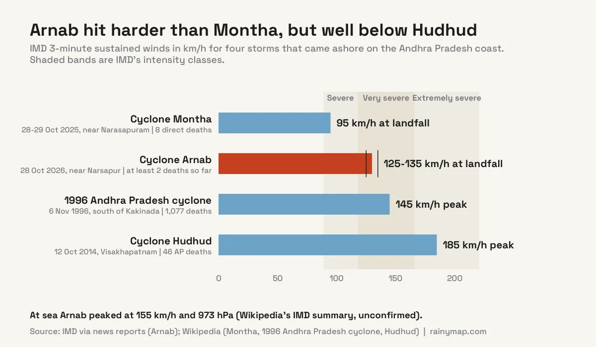
Arnab is stronger than Montha, which hit the same coast a year ago, but weaker than the two deadliest storms to cross this part of the coast in recent decades.
| Storm | Landfall | Wind, deaths and damage |
|---|---|---|
| Arnab | 28 Oct 2026, near Narsapur | Peak 135 km/h; 2 to 3 deaths so far; 31 houses damaged; full damage not yet counted |
| Montha | 28–29 Oct 2025, near Narasapuram | 95 km/h, 988 hPa; 8 direct deaths (2 in Andhra Pradesh, 6 in Telangana); about ₹6,384 crore (US$680 million) damage; 419 mm of rain at Bheemadevarpalle, Telangana |
| Hudhud | 12 Oct 2014, Visakhapatnam | 185 km/h, 950 hPa; 46 deaths in Andhra Pradesh (116 including Nepal); US$11 billion damage; Visakhapatnam airport closed for six days |
| 1996 cyclone | 6 Nov 1996, about 50 km south of Kakinada | 145 km/h; 1,077 confirmed deaths; 2 m storm surge; about US$602 million damage |
The comparison shows how wide the range of outcomes is. The 1996 storm killed more than a thousand people on this coast, while Hudhud killed 46 in Andhra Pradesh in 2014 after about 111,000 people were evacuated before landfall. Arnab’s death toll is, so far, two or three. It is far too early to call the damage, though: the final cost of Montha was only revised 12 days after landfall.
Was There a “Cyclone Arnab” in September 2026?
No. In September, media and social posts used the name Arnab for a Bay of Bengal system that never became a cyclone. That system crossed the Andhra Pradesh–Odisha coast near Kalingapatnam on the night of 23–24 September as a deep depression, with winds of 55–65 km/h gusting to 75 km/h, below the 63 km/h cyclonic-storm line. IMD kept it at deep-depression status and did not name it, even though the US Joint Typhoon Warning Center briefly tracked it as Tropical Cyclone 01B. The first system IMD actually named Arnab is the one that struck on 28 October.
Cyclone Arnab Forecast: What Happens Next?
- Weakening. Arnab fell to a severe cyclonic storm by late morning. IMD expects winds of 50–60 km/h by evening and the NDRF expects a deep depression by then, as it moves inland, first north-west and then north-north-west across Andhra Pradesh, south Odisha, Chhattisgarh and Telangana.
- Heavy rain keeps moving north. Very heavy rain in Odisha on 29 October, then heavy rain with thunderstorms and lightning on 30 October, and heavy rain in parts of West Bengal until 31 October. Flooding in rivers and low-lying areas often peaks a day or more after the storm passes.
- Seas stay dangerous. Sea conditions are “phenomenal” over the west-central Bay of Bengal on 28 October, easing to very rough or rough by evening. Fishermen are advised to stay ashore until 29 October along the Andhra Pradesh, Odisha and West Bengal coasts.
- Storm surge. IMD warned that a surge of 1–1.5 m above the normal tide could flood low-lying coastal areas of Andhra Pradesh during landfall.
The official source is IMD’s cyclone warning pages.
Why Do Cyclones Hit Andhra Pradesh in October?
The North Indian Ocean has two cyclone seasons, one before the summer monsoon (April–June) and one after it (October–December). In the post-monsoon season the Bay of Bengal’s surface water is still very warm, and storms form over it and are steered west or north-west towards India’s east coast. The Godavari and Krishna river deltas of Andhra Pradesh are flat and low, so a surge of even a metre or two can push seawater far inland. The same ingredients feed hurricanes in the Atlantic, as in our report on Hurricane Isaias.
Is a cyclone the same as a hurricane or a typhoon?
Yes. A tropical cyclone is called a hurricane in the Atlantic and north-east Pacific, a typhoon in the north-west Pacific and a cyclone in the North Indian Ocean and South Pacific. The physics are the same; only the name and the wind-speed scale change. Our explainer on how to track a hurricane in real time works for any basin.
Travel and Safety: What Should You Do?
- Check before you travel. Three Andhra Pradesh airports were suspended on 28 October. Confirm flights and trains with your airline and railway operator before heading to Visakhapatnam, Kakinada, Rajahmundry, Vijayawada, Puri or Bhubaneswar. Roads can be blocked by fallen trees for a day or more.
- Stay off beaches and out of the sea. Rough seas and surge continue after the wind eases, and Puri restricted sea bathing during the September system.
- Treat fallen wires as live. The two deaths confirmed with details were both electrocutions from live wires. Do not touch cables, poles or standing water near them.
- Do not go out in the calm of the eye. If the eye passes over you, the wind returns, often just as strong, from the opposite direction.
- Know the numbers. India’s national emergency number is 112. Outlook Traveller listed 1070 and 1800-425-0101 for the Andhra Pradesh state control room, 0674-2534177 for Odisha’s emergency operations centre and 1800-180-1717 for IMD; confirm them with local authorities.
Our hurricane preparedness checklist covers what to pack, what to move and what to do when water rises.
Follow Cyclone Arnab Live
RainyMap’s Andhra Pradesh radar and Odisha radar pages show where rain is falling right now, as does the global live rain map; the live wind map shows the circulation. Radar shows rain, not storm intensity, and satellite images like NASA’s Worldview show the cloud shield and eye. For evacuation and travel decisions, follow IMD, the Andhra Pradesh and Odisha disaster management authorities and 112.
Frequently Asked Questions
Where did Cyclone Arnab make landfall?
Cyclone Arnab began crossing the Andhra Pradesh coast at about 01:20 IST on Wednesday 28 October 2026 and finished in the late morning. IMD placed the crossing point about 20 km east-northeast of Narsapur (Narasapuram) and 40 km south-west of Yanam, between Bapatla and Visakhapatnam.
How strong is Cyclone Arnab?
IMD classes Arnab as a very severe cyclonic storm. It reported sustained winds of 125–135 km/h at 08:30 IST on 28 October and a peak of 135 km/h with gusts up to 150 km/h at landfall. The storm weakened to a severe cyclonic storm by late morning as it moved inland.
How many people have died in Cyclone Arnab?
At least two people have died and the NDRF says three, all in Andhra Pradesh, according to reports on 28 October. The two deaths with details were electrocutions from live wires, one in Anakapalli district. Odisha reported no serious impact in preliminary NDRF reports. The toll may change as damage assessments continue.
Which states are affected by Cyclone Arnab?
Andhra Pradesh is worst hit. IMD also warned of heavy to extremely heavy rain in south Odisha, south Chhattisgarh and north-east Telangana, with rain and squally weather in Jharkhand and South Bengal. Nepal has advised tourists to avoid high-altitude areas from Thursday night to Saturday.
Who named Cyclone Arnab, and what does Arnab mean?
Bangladesh proposed the name, which was added to the North Indian Ocean list adopted in April 2020. Arnab means “ocean” or “sea” in Bengali. IMD named the storm on 26 October when it reached cyclonic-storm strength.
How much rain has Cyclone Arnab brought?
Visakhapatnam recorded 216.9 mm in the 21 hours to 05:30 IST on 28 October, Kalingapatnam 147.5 mm, Tuni 123.3 mm and Kakinada 118.4 mm, according to IMD station data. IMD warned of extremely heavy rain (21 cm or more) at isolated places in coastal Andhra Pradesh, south Odisha and south Chhattisgarh.
How many people were evacuated?
Reuters reported more than 180,000 people evacuated in Andhra Pradesh and Odisha combined. About 400,000 needed to leave Andhra Pradesh, where nearly 50,000 were in shelters by Monday night and about 57,000 in relief camps on Wednesday, according to PTI. Odisha figures range from 30,000 to about 100,000.
Is Cyclone Arnab still active?
Yes, but it is weakening over land. It fell to a severe cyclonic storm by late morning, IMD expects winds of 50–60 km/h by evening and the NDRF expects a deep depression by then. Very heavy rain is forecast in Odisha on 29 October.
Will Cyclone Arnab hit Odisha, Kolkata or West Bengal?
Landfall has happened in Andhra Pradesh, so Odisha and West Bengal will not see the eye. Odisha is forecast to get very heavy rain on 29 October and heavy rain on 30 October, with gusts up to 80 km/h in the south. Earlier forecasts put South Bengal, including Kolkata, in line for rain and gusty winds on 28 and 29 October.
Was there a Cyclone Arnab in September 2026?
No. A deep depression that crossed the Andhra Pradesh–Odisha coast on 23–24 September was called “Cyclone Arnab” in some media and on social platforms, but IMD never named it because it stayed below cyclonic-storm strength. The first storm IMD named Arnab is the one that made landfall on 28 October.
How does Cyclone Arnab compare with Cyclone Montha?
Both storms crossed the Godavari delta coast near Narasapuram, almost exactly a year apart. Arnab’s landfall winds of 125–135 km/h are stronger than Montha’s 95 km/h, and IMD classes Arnab as a very severe cyclonic storm against Montha’s severe cyclonic storm. Montha killed 8 people directly and caused about US$680 million in damage; Arnab has killed two or three so far, and its damage is still being counted.
Is it safe to travel to Visakhapatnam, Kakinada or Puri?
Not on 28 October. Three Andhra Pradesh airports were suspended, trains have been cancelled, roads may be blocked and the sea is dangerous. Check with your airline or railway operator, follow state authorities, and expect delays for a day or two while debris is cleared and power is restored.
Why is Nepal warning trekkers about Cyclone Arnab?
Nepal said the storm could bring heavy rain, snowstorms and avalanches in the Himalayas. It advised tourists to avoid high-altitude areas from Thursday night to Saturday and suspended trekking permits for high mountain areas for three days. Check our guide to the best time to visit Nepal before you plan a trek.
How can I track Cyclone Arnab live?
Use RainyMap’s live radar for Kakinada, Visakhapatnam, Andhra Pradesh and Odisha to see the rain, the live wind map for circulation, and IMD’s cyclone warning pages for the official track and bulletins.
Sources
- The Week: Cyclone Arnab brings heavy rain to Andhra, Odisha; two dead (28 Oct)
- ETV Bharat: Cyclone Arnab live updates (28 Oct)
- DT Next (PTI): Andhra worst hit by Cyclone Arnab, 3 killed (28 Oct)
- NBC News (Reuters): India evacuates over 180,000 as Cyclone Arnab hits coast (28 Oct)
- Al Jazeera (AFP and Reuters): India evacuates tens of thousands as “very severe” Cyclone Arnab nears (27 Oct)
- India.com: Cyclone Arnab live, landfall near Narsapur and IMD station rainfall (28 Oct)
- ANI: Cyclone Arnab completes landfall in Andhra Pradesh, IMD warns of heavy rainfall in Odisha (28 Oct)
- Vajiram & Ravi: Cyclone Arnab 2026, summary of IMD bulletins (28 Oct)
- The Hans India: Cyclone Arnab, AP on alert as IMD warns of severe cyclonic storm (26 Oct)
- OdishaBytes: From depression to very severe cyclone, how Arnab will traverse the Bay of Bengal (25 Oct)
- DT Next: Cyclone Arnab likely to intensify into very severe storm, cross Andhra coast on Oct 28 (25 Oct)
- The Week: Cyclone Arnab to bring heavy rain, storms to Bengal and Odisha (24 Oct)
- OdishaBytes: Cyclone Arnab ruled out as IMD keeps deep depression status (23 Sept)
- Outlook Traveller: Cyclone Arnab travel advisory and emergency numbers (24 Sept)
- Wikipedia: 2026 North Indian Ocean cyclone season
- Wikipedia: Tropical cyclone scales (IMD categories)
- Wikipedia: Cyclone Montha
- Wikipedia: Cyclone Hudhud
- Wikipedia: 1996 Andhra Pradesh cyclone
- NASA Worldview (EOSDIS): MODIS Terra true-colour imagery, 27 Oct 2026
- India Meteorological Department: cyclone warnings and bulletins