Last updated: 10 October 2026, 21:00 UTC. Track and intensity from the US National Hurricane Center (NHC). The record analysis is RainyMap’s own, from NOAA’s HURDAT2 hurricane database (1851–2025). Impact figures are preliminary and may change as damage surveys continue.
Quick Answer
Hurricane Isaias became the first hurricane of the 2026 Atlantic season at 03:30 UTC on 8 October 2026 (10:30 pm CDT on 7 October). No Atlantic season in 176 years of records has waited longer for its first hurricane. The only comparable year is 1905, whose first hurricane is logged at 00:00 UTC on 8 October 1905, just 3.5 hours earlier on the calendar. That is why most forecasters call it a tie. Isaias formed in the south-west Gulf of Mexico. In 48 hours it strengthened from a 45 mph tropical storm into a 120 mph Category 3 major hurricane. It made landfall near Destin, Florida, at about 8:30 pm CDT on 9 October as a Category 2 hurricane with 105 mph winds. It brought a 5.6 ft storm surge to Panama City Beach, gusts up to 118 mph and more than 12 inches of rain in Florida and Alabama. At the peak about 929,000 customers lost power, and at least four people died. The season started so late because of a strong El Niño, which loaded the Atlantic with storm-shredding wind shear and dry, sinking air for most of the summer.
Isaias at a Glance
| Tropical depression | 21:00 UTC 6 October, south-west Gulf of Mexico |
| Named tropical storm | 09:00 UTC 7 October, the ninth named storm of 2026 |
| Became a hurricane | 03:30 UTC 8 October, the first hurricane of 2026 |
| Peak strength | Category 3, 120 mph (195 km/h), 958 mb, 9 October |
| Landfall | Near Destin, Florida, about 8:30 pm CDT 9 October (01:30 UTC 10 October); Category 2, 105 mph (169 km/h), 971 mb |
| Post-tropical | Over southern Alabama, about 2 am EDT 10 October |
| Highest gust | 118 mph (190 km/h) near Jay, Florida |
| Peak storm surge | 5.6 ft (1.7 m) above normal at Panama City Beach |
| Most rain | 12.46 in (316 mm) at DeFuniak Springs, Florida; over 12 in at Bellwood, Alabama |
| Power cuts | About 929,000 customers at the peak, mainly in Florida, Alabama and Georgia |
| Deaths | At least 4: two in Florida, two in Alabama |
A Record Last Seen in 1905
In a normal Atlantic season the first hurricane comes long before October. NHC’s 1991–2020 climatology puts the average first hurricane on 11 August and the first major hurricane on 1 September. Our own count from HURDAT2 gives a median of 9 August for the same 30 years. In 2026 the Atlantic went through June, July, August and all of September without a single hurricane, even though eight named storms formed in that time.
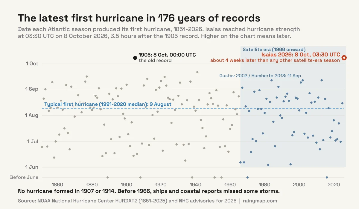
We checked every season in HURDAT2, NOAA’s official record of Atlantic storms back to 1851. Before 2026, only three seasons had reached October without a hurricane:
- 1905, whose only hurricane formed on 8 October;
- 1907 and 1914, which never produced a hurricane at all.
The next-latest first hurricane in the whole record came on 21 September 1941. Since 1966, when weather satellites began watching the tropics every day, the latest had been 11 September (Gustav in 2002 and Humberto in 2013). Isaias beat that by nearly four weeks.
Tie or new record?
Both, depending on how closely you look. HURDAT2 first lists the 1905 storm at hurricane strength at 00:00 UTC on 8 October 1905. NHC upgraded Isaias at 03:30 UTC on 8 October 2026, using data from Hurricane Hunter aircraft. By the clock, Isaias is 3.5 hours later. Most reports, including CBS News, call it a tie, and that is the fairer reading. The 1905 storm was tracked from ship reports and island weather stations, with no satellites and no aircraft. Its winds are rounded to 5 knots at six-hourly steps: it sat at 60 knots, just below hurricane strength, for 42 hours before the record shows 65 knots. Old data like that cannot pin down the moment it crossed the line to within 3.5 hours.
The calendar adds a second wrinkle. In US Central time Isaias became a hurricane at 10:30 pm on 7 October, so some American outlets give its date as 7 October. Meteorologists compare storms in UTC, which puts both 1905 and 2026 on 8 October.
The two storms also peaked the same way. According to HURDAT2, the 1905 hurricane, which had crossed the Caribbean and the south-eastern Bahamas as a tropical storm, reached 105 knots (120 mph), a Category 3, on 9 October 1905, out over the open Atlantic just after passing south of Bermuda. Isaias reached exactly 105 knots on 9 October 2026, over the Gulf. The big difference is that the 1905 storm never hit land as a hurricane, while Isaias hit the Florida Panhandle.
From Gulf Depression to Major Hurricane in Two Days
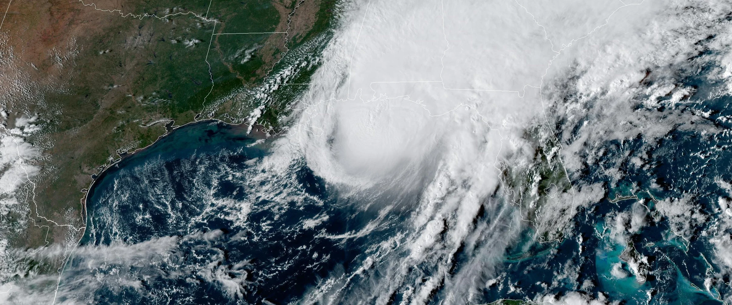
Isaias grew out of a weak low that sat almost still off the coast of north-east Mexico from 4 to 6 October. NHC began watching the area on 3 October and labelled it Invest 92L on the 5th. It organised into Tropical Depression Nine on the afternoon of 6 October and began to drift east-north-east. Once it became Tropical Storm Isaias on the 7th, it curved north towards the Florida Panhandle.
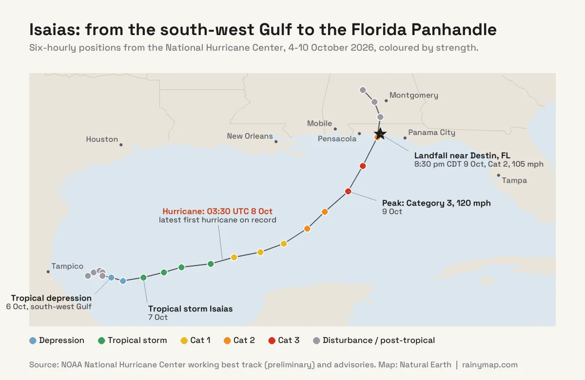
Over the warm central Gulf it intensified very fast. In NHC’s working best track, the winds rose from 40 knots (45 mph) at 12:00 UTC on 7 October to 75 knots (85 mph) a day later. By 12:00 UTC on 9 October they reached 105 knots (120 mph). Forecasters call an increase of at least 30 knots in 24 hours rapid intensification, and Isaias did it two days running. Its central pressure fell from 1002 mb to 959 mb over the same 48 hours.
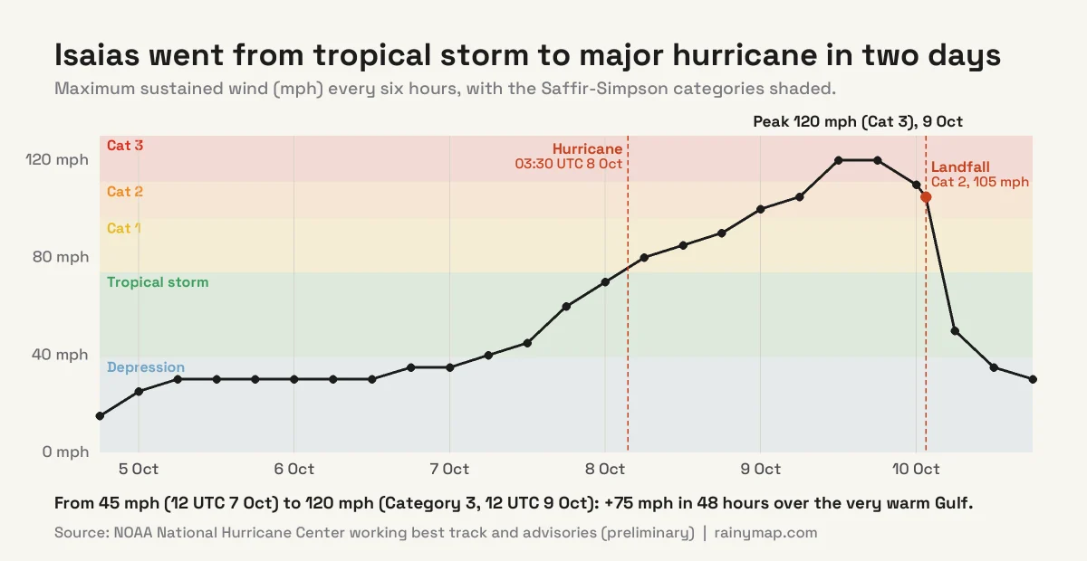
Isaias weakened a little in its last hours over water, from 120 mph to 105 mph. It still came ashore near Destin as a strong Category 2 at about 8:30 pm CDT (9:30 pm EDT) on Friday 9 October. Over land it lost its warm-ocean fuel quickly. Within about four and a half hours NHC declared it post-tropical over southern Alabama, at around 2 am EDT on Saturday 10 October. It was the first hurricane to make landfall in the United States since Milton, which struck Florida two years earlier to the day, on 9 October 2024.
Landfall and Impacts
Storm surge
The highest water was east of the landfall point. The surge at Panama City Beach, about 45 miles (70 km) east of Destin, peaked at 5.6 ft (1.7 m) above normal at around 9:30 pm EDT. That pattern is typical. In the Northern Hemisphere a hurricane’s winds turn anticlockwise, so on the right-hand side of its track they blow straight onshore and pile water against the coast. For a storm heading north, the right-hand side is the east.
Wind
The strongest gusts hit the Pensacola area and inland Santa Rosa County:
- 118 mph (190 km/h) near Jay, Florida, close to the Alabama border
- 116 mph (187 km/h) at Santa Rosa Sound, with sustained winds of 91 mph
- 102 mph (164 km/h) at Pensacola City Hall
- 96 mph (154 km/h) at Fair Point Light on Pensacola Bay
Falling trees brought down power lines across the region and caused at least two of the deaths.
Rain and flooding
Isaias was a wet storm. DeFuniak Springs in the Florida Panhandle measured 12.46 inches (316 mm), and Bellwood in southern Alabama passed 12 inches. Forecasters warned that totals of up to 15 inches were possible in places as the remnants moved north towards the Tennessee Valley and the southern Appalachians. Flash flooding is often the deadliest part of a hurricane once it moves inland. Our live rain map shows where the heaviest bands are falling right now.
Power cuts
Outages peaked on Saturday morning at about 929,000 homes and businesses, more than a million people. Early Saturday, CBS News counted about 430,000 customers without power in Florida, 326,000 in Alabama and 128,000 in Georgia. Escambia County, home to Pensacola, had the largest number of outages in Florida, about 130,000. By Saturday afternoon more than 420,000 Florida customers were still waiting for power to come back.
Deaths
At least four people died. In Escambia County, Florida, a woman was killed when a tree fell on her home, and a man died of carbon monoxide poisoning from a generator running in a closed garage; four other people were taken to hospital. In Alabama, a tree fell on a house in the Birmingham area, killing one person, and a second death was confirmed in Barbour County. Carbon monoxide deaths after hurricanes are common and preventable: always run generators outdoors, at least 20 feet from windows and doors.
Tornadoes
Like most landfalling hurricanes, Isaias spun up tornado threats in its outer bands. Tornado watches covered the Florida Panhandle, the Big Bend, north Florida and southern Georgia overnight, then eastern Georgia and South Carolina through Saturday evening. The first tornado warning on Saturday was issued for Screven County in south-east Georgia.
Why the Atlantic Waited Until October: El Niño
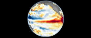
The main reason for the late start is a powerful El Niño in the Pacific. In its 8 October update, NOAA’s Climate Prediction Center put the chance of this El Niño reaching historic strength in October to December at 83%. We cover what that means for winter weather in our Super El Niño 2026 guide.
El Niño suppresses Atlantic hurricanes in two ways, as atmospheric scientist Christopher Davis of the University of Massachusetts Amherst explains in The Conversation:
- Wind shear. Unusually warm water in the eastern Pacific shifts where tropical air rises. Strong westerly winds then flow high over Central America, the Caribbean and the tropical Atlantic. Those upper winds blow across the tops of developing storms and tear them apart before they can organise. This is vertical wind shear.
- Dry, sinking air. The air that rises over the Pacific has to come down somewhere, and some of it sinks over the tropical Atlantic. Sinking air warms and dries out, which chokes off the deep thunderstorms a hurricane needs.
The result was a season of short-lived, mostly weak storms. Most of the eight named storms before Isaias formed at higher latitudes, where strong hurricanes rarely develop. In July, Colorado State University’s forecasters cut their outlook to 9 named storms, 4 hurricanes and 1 major hurricane. The named-storm count has now been reached, but Isaias is the only hurricane. Our July article on why the 2026 season went quiet covers the early months, and our El Niño and La Niña explainer explains the Pacific side.
How Isaias Broke Through
Isaias formed in the one corner of the basin where conditions briefly turned in its favour. In early October, the vertical wind shear over the western Gulf weakened. A pocket of moist air moved over the area, and the Gulf was still exceptionally warm after the summer. That was enough for a slow-moving low off Mexico to organise, then intensify rapidly once it moved over the deep warm water of the central Gulf.
It also fits the usual October pattern. As the season gets late, storms tend to form closer to home, in the Gulf and the western Caribbean, rather than in the far tropical Atlantic between Africa and the Caribbean, where El Niño’s shear is strongest. Storms that form close to land leave less time for warnings, which is why late-season hurricanes can reach the coast only a few days after they first appear. Isaias went from tropical depression to landfall in about three days.
What Comes Next: Is the 2026 Hurricane Season Over?
No. The Atlantic season officially runs until 30 November, and the next names on the 2026 list are Josephine, Kyle and Leah. With El Niño still strengthening, high wind shear will probably keep most of the Atlantic hostile for the rest of the season. The Gulf and western Caribbean stay warm well into autumn, though, and Isaias has just shown that one storm in the right place is enough.
A quiet season is not a safe season. By hurricane count, 2026 is shaping up as one of the quietest Atlantic seasons on record. For the Florida Panhandle and Alabama it will be remembered for a Category 2 landfall, four deaths and nearly a million homes and businesses in the dark.
How to Follow the Next Storm on RainyMap
- Live wind map: see a storm’s circulation and the size of its wind field as it approaches the coast.
- Live rain map: follow the rain bands spiralling in from the Gulf and spot slow-moving downpours that cause flash floods.
- Live lightning map: lightning bursts near a hurricane’s centre can signal strengthening. Our guide on how to read a lightning map explains the colours.
- Guides: how to track a hurricane in real time and our hurricane preparedness checklist.
Maps help you understand a storm, but decisions about evacuating or sheltering should always follow the National Hurricane Center and your local National Weather Service office and emergency managers.
Frequently Asked Questions
When did Isaias become a hurricane?
Isaias became a hurricane at 03:30 UTC on 8 October 2026, which was 10:30 pm CDT on 7 October in the US. It was the first hurricane of the 2026 Atlantic season and formed over the central Gulf of Mexico.
Did Hurricane Isaias break the record for the latest first hurricane?
It matched it, and by the clock slightly beat it. The previous latest first hurricane formed at 00:00 UTC on 8 October 1905; Isaias reached hurricane strength 3.5 hours later on the same date. Because the 1905 data are much less precise, most forecasters describe it as a tie. Since satellite monitoring began in 1966, no other season had waited past 11 September.
Where did Hurricane Isaias make landfall?
Isaias made landfall near Destin, Florida, on the Florida Panhandle, at about 8:30 pm CDT (9:30 pm EDT) on Friday 9 October 2026. It was a Category 2 hurricane with maximum sustained winds of 105 mph and a central pressure of 971 mb.
How strong did Hurricane Isaias get?
Isaias peaked on 9 October as a Category 3 major hurricane with maximum sustained winds of 120 mph (195 km/h) and a minimum pressure of about 958 mb. It was the first major hurricane of the 2026 Atlantic season. It weakened slightly to Category 2 before landfall.
How many people died in Hurricane Isaias?
At least four people died: two in Escambia County, Florida, one from a falling tree and one from carbon monoxide from a generator, and two in Alabama, including a person killed when a tree fell on a house near Birmingham. These are preliminary figures.
How many people lost power during Hurricane Isaias?
About 929,000 customer accounts, covering more than a million people, were without power at the peak on Saturday morning, 10 October. Florida had about 430,000 outages, Alabama about 326,000 and Georgia about 128,000.
Why was the 2026 Atlantic hurricane season so quiet?
A strong El Niño in the Pacific increased vertical wind shear over the Atlantic and Caribbean and made the air over the tropical Atlantic drier and more stable. Both conditions tear apart or starve developing storms, so the eight named storms before Isaias stayed weak and short-lived.
Is this the same Hurricane Isaias as in 2020?
No. Atlantic storm names are reused every six years unless retired, and Isaias was not retired after 2020. The 2020 Hurricane Isaias made landfall in North Carolina as a Category 1 hurricane in August 2020. The 2026 Isaias formed in the Gulf of Mexico and hit the Florida Panhandle in October 2026.
What is the next hurricane name in 2026?
The next names on the 2026 Atlantic list are Josephine, Kyle and Leah. Leah replaced Laura, which was retired after the destructive 2020 hurricane.
When does the 2026 Atlantic hurricane season end?
The Atlantic hurricane season officially ends on 30 November 2026. Storms can still form in October and November, especially in the Gulf of Mexico and the western Caribbean, where the water stays warm late into the year.
Sources
- National Hurricane Center: 2026 Atlantic advisories archive (Isaias)
- National Hurricane Center: working best track for Isaias (AL09 2026, preliminary)
- National Hurricane Center: HURDAT2 Atlantic hurricane database, 1851–2025
- National Hurricane Center: tropical cyclone climatology (1991–2020 averages)
- CBS News: Isaias becomes the 2026 Atlantic season’s first hurricane, tying a 1905 record
- CBS News: live updates on deaths, outages and flooding
- Fox Weather: live updates with measured gusts, surge and rainfall
- NPR: Hurricane Isaias updates
- WFTV: Florida outages and recovery
- The Conversation (Christopher Davis, UMass Amherst): how Isaias broke through in an eerily quiet season
- NOAA Climate Prediction Center: ENSO diagnostic discussion
- The Watchers: NOAA gives El Niño an 83% chance of reaching historic strength
- The Weather Channel: Colorado State University’s July 2026 outlook
- NOAA/NESDIS STAR: GOES-19 GeoColor satellite imagery (featured image)