Last updated: 11 October 2026. Earthquake data from the US Geological Survey (USGS); damage figures from Panama’s National Civil Protection System (SINAPROC) and news agencies. Figures are preliminary and may change as assessments continue.
Quick Answer
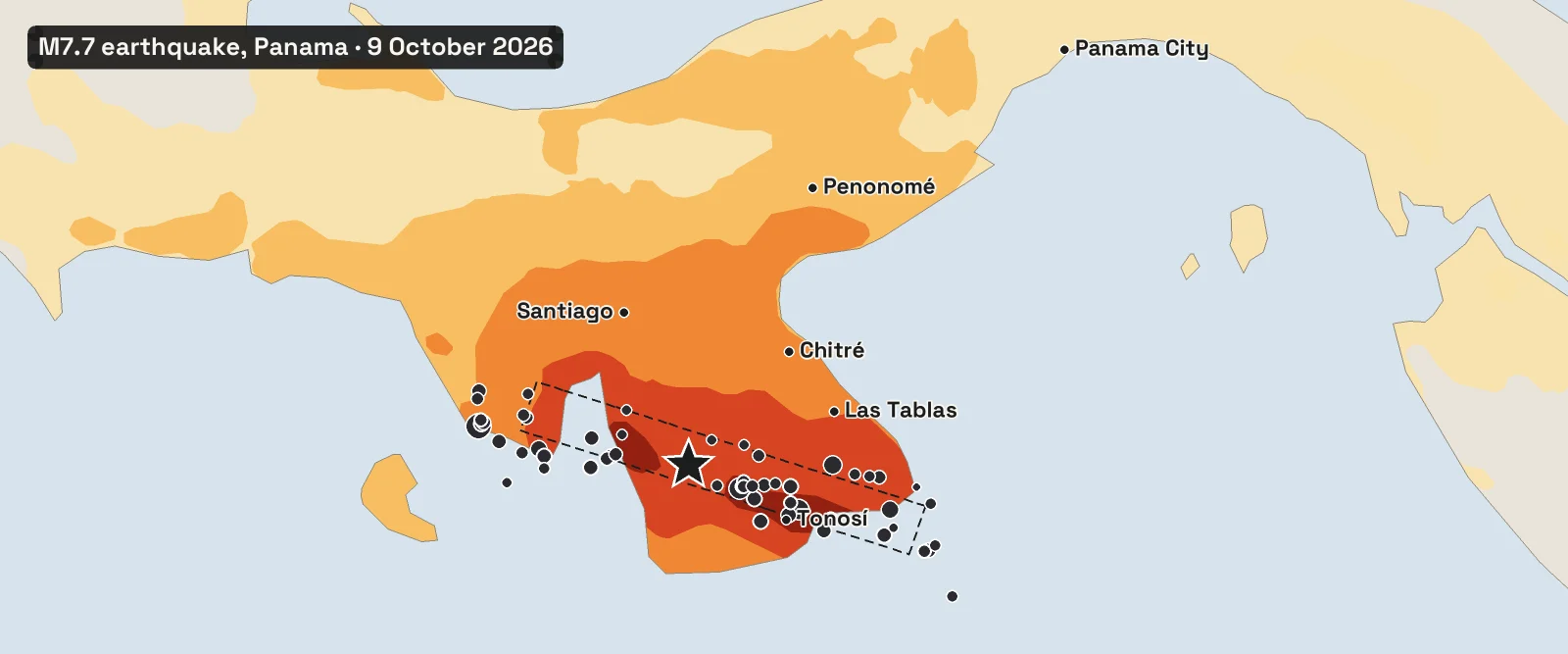
A magnitude 7.7 earthquake struck Panama’s Azuero Peninsula at 12:56 pm local time on Friday 9 October 2026 (17:56 UTC), according to the USGS. The epicentre was in southern Herrera Province, about 200 km (125 miles) south-west of Panama City, at a shallow depth of 12.6 km. Panama’s own Geosciences Institute measured it at magnitude 7.2. It was the strongest earthquake within 500 km of the epicentre in the USGS record since 1900. The shaking reached intensity IX (violent) around Tonosí and VIII (severe) in Las Tablas and Pedasí. As of 10 October, SINAPROC reported no deaths, 27 injured, 426 damaged homes and 419 affected schools. The government declared a state of emergency. A brief tsunami threat was lifted within two hours, and the Panama Canal kept operating. More than 50 aftershocks of magnitude 4 or above followed in the first 33 hours, the largest a magnitude 6.6. The USGS puts the chance of another magnitude 6 or larger within a week at about 50%.
Panama Earthquake at a Glance
| Date and time | Friday 9 October 2026, 12:56 pm local time (17:56 UTC) |
| Magnitude | 7.7 (USGS moment magnitude); 7.2 (Panama’s Geosciences Institute) |
| Epicentre | 12 km WSW of Pitaloza Arriba, southern Herrera Province, Azuero Peninsula |
| Depth | 12.6 km (7.8 miles), a shallow earthquake |
| Fault type | Left-lateral strike-slip, on a fault running west-north-west |
| Strongest shaking | Intensity IX (violent) around Tonosí, Los Santos |
| People in strong shaking | About 4.7 million at intensity V or above; about 590,000 at VII or above |
| Casualties | No deaths reported; 27 injured (SINAPROC, 10 October) |
| Damage | 426 homes, 419 schools, 21 health centres, 9 bridges; about 2,130 people affected |
| Largest aftershock | Magnitude 6.6 at 3:25 pm local time on 9 October |
| Tsunami | Threat issued for Panama’s Pacific coast, ended at 2:40 pm local time; no damaging waves reported |
Where the Shaking Was Strongest
The earthquake ruptured a fault beneath the south of the Azuero Peninsula, the broad peninsula that juts into the Pacific between the Gulf of Panama and the Gulf of Montijo. The USGS ShakeMap, which combines seismic recordings with reports from people (more than 1,200 have answered the USGS “Did You Feel It?” survey), shows the strongest shaking in a band along the fault from western Los Santos to southern Veraguas.
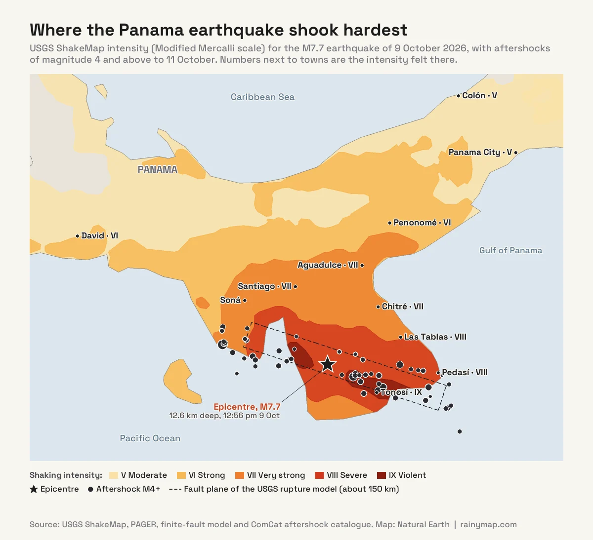
Intensity measures what people felt and what buildings went through at a particular place, on the Modified Mercalli scale from I to X. That makes it different from magnitude, which is a single number for the whole earthquake. USGS estimates for towns across central Panama:
- Intensity IX (violent): Tonosí and the surrounding countryside in southern Los Santos.
- Intensity VIII (severe): Las Tablas, Pedasí and Macaracas.
- Intensity VII (very strong): Chitré, Santiago and Aguadulce.
- Intensity VI (strong): Penonomé, and David at the V–VI boundary.
- Intensity V (moderate): Panama City, San Miguelito and Colón.
The shaking was felt across Panama and into Costa Rica and Colombia. In San José, Costa Rica, about 450 km away, the USGS estimates intensity III to IV: clearly felt, but not damaging.
Why are there two different magnitudes?
The USGS gives 7.7, while the Geosciences Institute of the University of Panama (IGC) settled on 7.2, after preliminary figures of 7.0 and 7.5. The USGS number is a moment magnitude, calculated from long-period seismic waves recorded worldwide; it reflects the total energy released by the fault and is the figure used internationally. Magnitude scales based on short-period waves, often used for quick local estimates, tend to underestimate very large earthquakes; seismologists say they “saturate”. Early automatic estimates ranged from 7.6 to 8.0 before the USGS settled on a reviewed 7.7. The two agencies also differ on depth: 12.6 km for the USGS, about 4 km for the IGC. Both describe a shallow earthquake, which is why the shaking at the surface was so strong. IGC director Néstor Luque said the shallow depth made the movement feel more intense at the surface.
How Many People Felt It
The USGS PAGER system combines the ShakeMap with population data to estimate how many people felt each level of shaking.
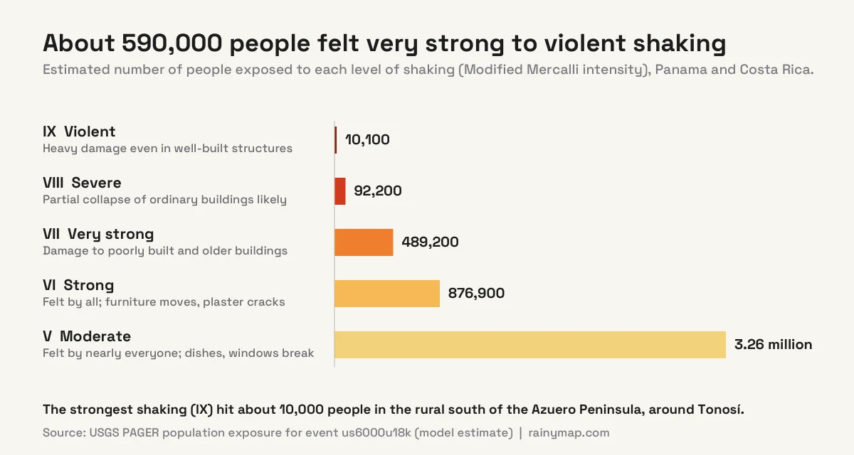
In total, about 4.7 million people felt at least moderate shaking, which is most of Panama’s population. Around 591,000 people were in very strong to violent shaking (intensity VII to IX), and about 10,000 in the worst-hit zone. PAGER issued a red alert for economic losses, with a central estimate of about US$3.6 billion. It issued a yellow alert for fatalities, meaning “some casualties are possible”. The USGS noted that the most common vulnerable buildings in the region are unreinforced brick masonry and adobe.
Damage, Injuries and the Response
According to SINAPROC’s assessment on Saturday 10 October:
- No deaths and no missing people had been reported.
- 27 people were injured, with minor to moderate injuries: 17 in Coclé, 6 in Los Santos, 2 in Panamá Oeste and 1 each in Herrera and Veraguas.
- 426 homes were damaged, affecting about 2,130 people.
- 419 schools and 21 health centres were affected, along with 13 churches, 7 hotels and 9 bridges.
- About 300 people were evacuated from Isla Caña in Los Santos after the sea rose and the surf turned rough.
The provinces of Herrera, Los Santos, Coclé and Veraguas were hit hardest, but the Associated Press reported damage in all ten provinces and two Indigenous territories. Landslides and damaged roads cut off several communities, including five in Los Santos and the towns of Arenas, El Cacao and Quebro in Veraguas. In Penonomé, one tower of the San Juan Bautista Cathedral collapsed, a whole side of the Coclé provincial government building came down, and the Hotel Dos Continentes was damaged. In La Villa de Los Santos, AP reported collapses at colonial-era homes and at the Church of San Atanasio, a national heritage site since 1938.
Power cuts hit six provinces, and about 66,000 people were still without electricity on Saturday. Schools and public offices were closed. Tocumen International Airport briefly suspended operations for safety checks, then reopened. The Panama Canal Authority said ships kept passing through the canal without interruption while staff inspected for damage.
On Saturday the government declared a state of emergency, authorising up to US$100 million for the response. President José Raúl Mulino visited the affected areas and set up a commission to coordinate relief. The United States pledged US$5 million in humanitarian aid, and two US helicopters delivered about 2,000 pounds (900 kg) of food. The development bank CAF donated US$250,000.
Why were there no deaths?
A magnitude 7.7 earthquake this shallow can be deadly, and the USGS loss model expected some fatalities. So far Panama has been spared. The exposure figures suggest one reason: the most violent shaking fell on a rural, thinly populated part of southern Azuero, where about 10,000 people live in the intensity IX zone. The biggest towns, Chitré, Santiago and Panama City, felt intensity VII or less. Damage counts and casualty figures can still change as teams reach isolated communities.
Was There a Tsunami?
Within about half an hour, the Pacific Tsunami Warning Center warned that waves of 1 to 3 metres (3.3 to 9.8 ft) above tide level were possible along parts of Panama’s coast. Smaller waves were possible from Mexico to Chile. The threat was declared over at 19:40 UTC (2:40 pm local time), and no damaging tsunami was reported. The US National Weather Service confirmed that no tsunami was expected on the US West Coast.
The type of fault explains much of this. Big tsunamis come from earthquakes that lift or drop the seafloor, as on subduction faults. In a strike-slip earthquake like this one, the two sides of the fault slide past each other horizontally, so much less water is pushed up. Much of the rupture was also under land. Even so, the evacuation of Isla Caña was the right call: near the coast, any earthquake strong enough to make standing difficult, or lasting 20 seconds or more, is reason to move to high ground without waiting for an official warning.
Why Panama Has Earthquakes
Panama sits on the Panama microplate, a small block of crust boxed in by four larger plates. The USGS describes the setting like this: along its southern boundary the Cocos plate dives beneath the microplate and the Nazca plate pushes against it at an angle, while along its northern boundary the Caribbean plate slides beneath it. To the west, the north-south Panama Fracture Zone separates the Cocos and Nazca plates, and most of the region’s past earthquakes happened there.
This earthquake was a left-lateral strike-slip event: looking across the fault, the far side moved to the left. The USGS moment tensor shows a fault running west-north-west across the peninsula. Its rupture model puts the slip on a fault plane about 150 km long, with up to 7.8 metres of movement. The aftershocks line up along the same trend, from the western coast of Azuero near the Gulf of Montijo to beyond Tonosí. According to Reuters, the IGC director linked the earthquake to stress built up in the Azuero-Soná fault system, a known fault zone along the southern edge of the microplate.
The Strongest Earthquake in the Region Since Records Began
We searched the USGS catalogue for every earthquake of magnitude 6.5 or more within 500 km of the epicentre since 1900. There were 57 between 1900 and 2025, about one every two years, but none as strong as this one.
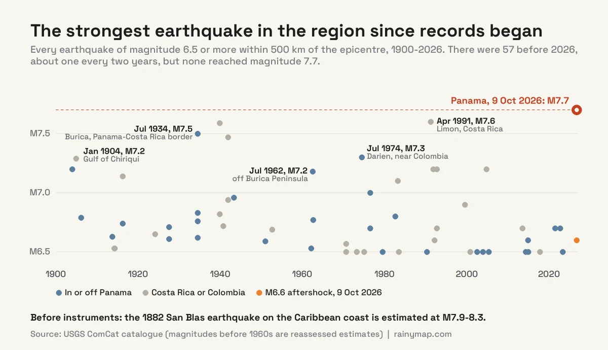
The closest rivals were the 1991 Limón earthquake in Costa Rica (magnitude 7.6), which also caused heavy damage in Panama’s Bocas del Toro province, and the 1934 earthquake near the Burica Peninsula on the Panama-Costa Rica border (7.5). Closer to Azuero, the largest earlier shocks were a magnitude 6.6 near Arenas in 1951, about 40 km from this epicentre, and a 6.6 near Pedasí in 1913.
It was not Panama’s largest earthquake ever. That was most likely the San Blas earthquake of 7 September 1882 on the Caribbean coast, estimated at magnitude 7.9 to 8.3. It caused a tsunami and about 250 deaths, before modern seismographs existed.
Aftershocks: What to Expect
Large aftershocks came quickly: a magnitude 5.5 after 26 minutes, a 5.8 after 42 minutes, then the largest so far, a magnitude 6.6, at 3:25 pm local time near the western end of the rupture. A magnitude 6.0 followed at 11:14 pm near La Tronosa, close to Tonosí. The USGS recorded 54 aftershocks of magnitude 4 or above in the first 33 hours, 14 of them magnitude 5 or more. Panama’s IGC, whose local network picks up smaller shocks, counted more than 150.
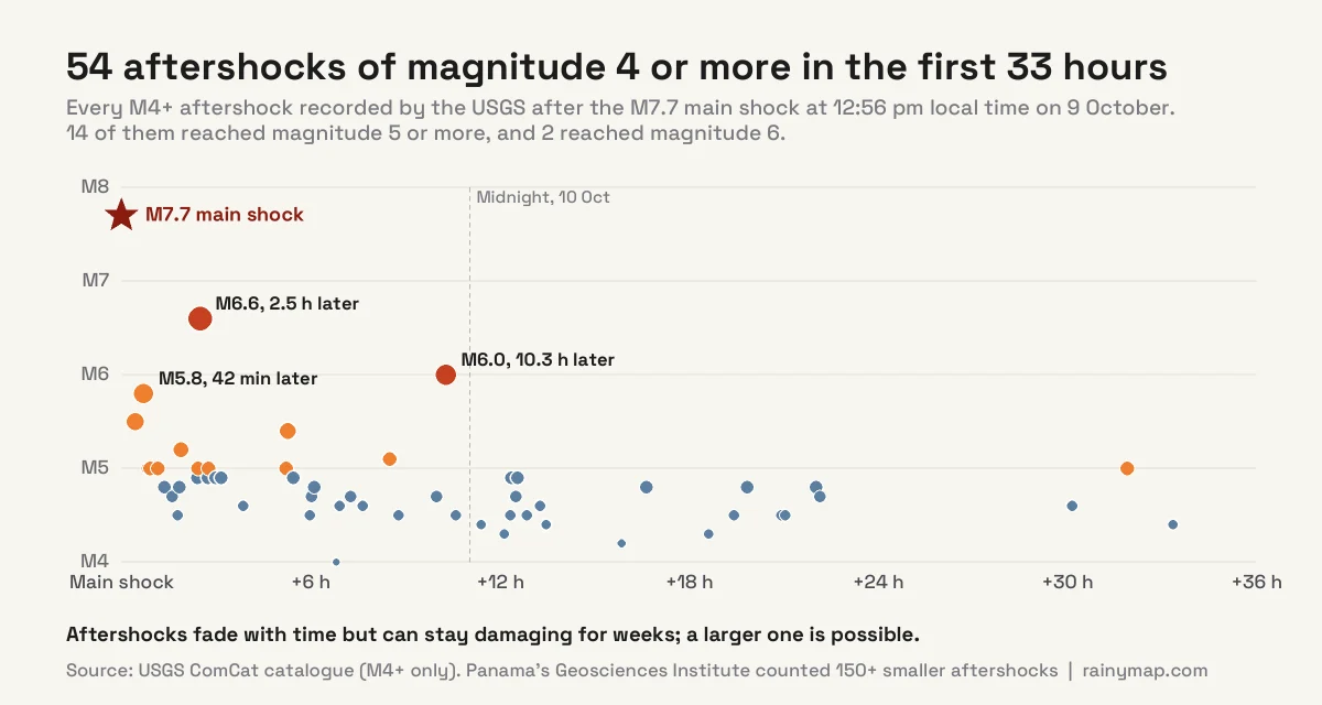
Aftershocks become less frequent over time, but they can continue for months, and a damaging one can strike weeks later. The USGS aftershock forecast, issued on 10 October, gives these odds:
| Time period | Expected M5+ aftershocks | Chance of M6+ | Chance of M7+ |
|---|---|---|---|
| Next day | 0 to 8 | 22% | 3% |
| Next week | 2 to 23 | 52% | 8% |
| Next month | 4 to 48 | 70% | 13% |
| Next year | 7 to 156 | 86% | 24% |
An 8% chance of a magnitude 7 or larger in the next week is low, but it is not zero. People in central Panama should treat damaged buildings as unsafe until they have been checked.
Landslides and the Rainy Season
The USGS ground-failure model issued a red alert for landslide hazard and an orange alert for liquefaction, where shaking turns waterlogged ground soft. It estimated that about 33,000 people live in areas exposed to liquefaction. Landslides have already cut roads to communities in Los Santos, Herrera and Veraguas.
The timing makes this worse. Panama’s rainy season runs roughly from May to November, and October is usually one of its wettest months. Slopes cracked by shaking can fail in heavy rain days or weeks after an earthquake. Anyone living below steep ground in the affected provinces should watch for new cracks, tilting trees or muddy water in streams, and move away during downpours. Our live rain map shows where heavy rain is falling over Panama right now.
What to Do in an Earthquake and Its Aftershocks
The internationally recommended response to shaking is Drop, Cover and Hold On:
- Drop to your hands and knees before the shaking knocks you down.
- Cover your head and neck under a sturdy table or desk, or against an interior wall away from windows.
- Hold on until the shaking stops. Do not run outside while the ground is moving; falling glass and masonry near exits cause many injuries.
After the shaking stops:
- Expect aftershocks, and stay out of buildings with visible cracks or damage until they have been inspected.
- Check for gas leaks and damaged wiring, and do not use open flames until you are sure.
- If you are on the coast and the shaking was strong or long, move to high ground straight away.
- Keep a kit with water, food, medicines, a torch and a battery radio. Our emergency preparedness checklist covers the essentials, which are the same for earthquakes and storms.
- Follow SINAPROC and official government channels for updates, and avoid sharing unverified rumours.
Frequently Asked Questions
When did the Panama earthquake happen?
The earthquake struck at 12:56 pm local time on Friday 9 October 2026, which was 17:56 UTC. Strong aftershocks followed the same afternoon and evening, including a magnitude 6.6 at 3:25 pm local time.
How strong was the Panama earthquake?
The USGS measured it at moment magnitude 7.7, and Panama’s Geosciences Institute at 7.2. The difference comes from different methods; the USGS moment magnitude is the standard international figure for large earthquakes. It was the strongest earthquake within 500 km of the epicentre in the USGS record since 1900.
Where was the epicentre of the Panama earthquake?
The epicentre was 12 km west-south-west of Pitaloza Arriba in southern Herrera Province, on the Azuero Peninsula, about 200 km south-west of Panama City. The IGC placed it about 39 km west of Tonosí in Los Santos. The depth was about 12.6 km.
How many people died in the Panama earthquake?
No deaths had been reported as of 10 October 2026. SINAPROC reported 27 people injured, most of them in Coclé and Los Santos, and 426 damaged homes. These figures are preliminary.
Was there a tsunami after the Panama earthquake?
The Pacific Tsunami Warning Center warned that waves of 1 to 3 metres were possible on parts of Panama’s coast, but the threat ended at 2:40 pm local time and no damaging tsunami was reported. About 300 people were evacuated from Isla Caña as a precaution.
Was the Panama Canal damaged by the earthquake?
No. The Panama Canal Authority said ships kept passing through the canal without interruption while staff inspected for damage. The canal is about 200 km north-east of the epicentre, where the shaking was moderate.
Why does Panama have earthquakes?
Panama lies on the Panama microplate, squeezed between the Cocos, Nazca, Caribbean and South American plates. This earthquake was a left-lateral strike-slip rupture on a fault running west-north-west across the Azuero Peninsula. Panama’s Geosciences Institute linked it to the Azuero-Soná fault system.
Will there be more aftershocks in Panama?
Yes. More than 150 aftershocks were recorded in the first day. The USGS forecast, issued on 10 October, gives about a 52% chance of an aftershock of magnitude 6 or larger within a week and about 8% for magnitude 7 or larger.
Is it safe to travel to Panama after the earthquake?
Panama City, the canal and Tocumen International Airport were operating, and the capital felt only moderate shaking. The central provinces of Herrera, Los Santos, Coclé and Veraguas have damaged roads, buildings and power cuts, and aftershocks continue. Check your government’s travel advice and SINAPROC updates before visiting those areas.
What was the biggest earthquake in Panama’s history?
The largest known was the San Blas earthquake of 7 September 1882 on the Caribbean coast, estimated at magnitude 7.9 to 8.3, which caused a tsunami and about 250 deaths. The 2026 Azuero earthquake is the strongest in or near Panama since instrumental records began around 1900.
Sources
- USGS: M 7.7 – 12 km WSW of Pitaloza Arriba, Panama (event page, tectonic summary)
- USGS ShakeMap: shaking intensity
- USGS PAGER: population exposure and loss estimates
- USGS aftershock forecast
- USGS ground failure: landslide and liquefaction estimates
- USGS ComCat earthquake catalogue (historical and aftershock search)
- Infobae: SINAPROC damage figures (in Spanish)
- Associated Press: Panama declares a state of emergency as aftershocks rattle communities
- Reuters (via The Jerusalem Post): Panama Canal shipping uninterrupted
- La Prensa: Geosciences Institute magnitude and aftershocks (in Spanish)
- The Watchers: Pacific Tsunami Warning Center bulletins
- ABC News: earthquake shakes Panama, tsunami threat subsides
- The Tico Times: aftershocks and power outages
- Newsweek: US West Coast tsunami status
- Wikipedia: 1882 Panama earthquake
- Earthquake Country Alliance: Drop, Cover and Hold On