Last updated: 4 September 2026.
Announcement artwork: Google DeepMind.
Quick Answer
Google DeepMind released WeatherNext 3 on 3 September 2026, and the headline change is not raw accuracy — it is resolution and speed. The model produces forecasts at 5 km resolution for surface temperature and moisture, updated every hour, against 25 km every six hours in WeatherNext 2. That is roughly five times sharper, refreshing six times more often. Google reports precipitation forecasts up to 50% more accurate a day or more ahead, and runs a 64-member, 15-day ensemble. The deeper change is architectural: WeatherNext 3 trains directly on raw satellite observations rather than the output of traditional weather models, which removes a six-hour data lag that has constrained forecasting for decades.
What Google Actually Announced
WeatherNext 3 is the third generation of DeepMind’s global weather model, and the changes are substantial enough that comparing it to its predecessor is the clearest way to understand it.
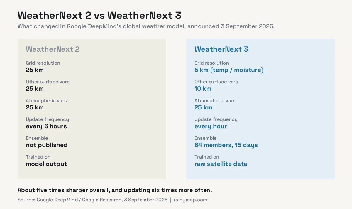
Resolution is not uniform across variables, which matters if you are reading the numbers carefully:
- 5 km — surface temperature and moisture
- 10 km — other surface variables
- 25 km — atmospheric variables such as wind
So “5 km resolution” is accurate for the variables most people check, but wind is still modelled on the older 25 km grid. Google describes the overall global picture as about five times sharper.
Under the hood it is a Functional Generative Network, building on the WeatherNext 2 architecture with a larger latent size (768 to 1024) and a deeper mesh transformer (24 to 32 layers), trained to minimise Continuous Ranked Probability Score — a measure of how well a probabilistic forecast matches what actually happened. It outputs gridded fields, discrete tropical cyclone tracks, and station-level predictions.
The Real Innovation: Skipping the Six-Hour Lag
This is the part worth understanding, because it explains why the improvement is larger than a normal version bump.
Traditional numerical weather prediction works in cycles. Observations are gathered, assimilated into a physical model of the atmosphere, and the model is run forward. That assimilation step is computationally enormous, which is why major global models run roughly every six hours. By the time a forecast is published, its starting conditions are already several hours old.
Most AI weather models inherited that limitation, because they were trained on reanalysis — the historical output of those same numerical models. They learned to imitate a system that was itself running six hours behind.
WeatherNext 3 breaks that chain by training directly on observations:
- Live geostationary satellite mosaics — 11 channels at 0.1-degree resolution, with roughly one hour of latency
- Surface observations from METAR stations, regional Mesonet networks, and ICOADS ship and buoy records going back to 2001
- Precipitation data from NASA’s IMERG satellite product and PARDIG, an experimental AI-generated reanalysis
The production model was trained on data through 30 June 2026. Because satellite imagery arrives within about an hour rather than six, the model can refresh hourly on genuinely current conditions. For fast-changing variables — convection, developing storms, precipitation onset — that difference compounds quickly.
How Much More Accurate Is It, Really?
Google reports gains across several categories. They are worth laying out individually, because the headline number does not tell the whole story.
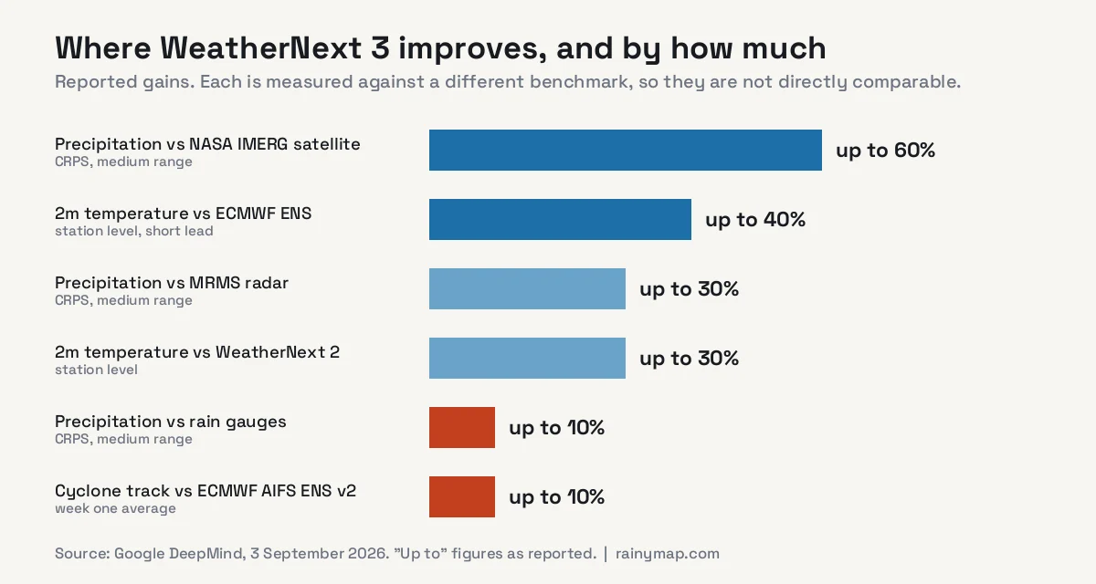
Precipitation, medium range: up to 60% CRPS improvement measured against NASA’s IMERG satellite product, 30% against MRMS radar, and 10% against rain gauges. The widely quoted “50% more accurate precipitation” refers to forecasts a day or more ahead.
Station-level temperature: up to 30% better than WeatherNext 2, and up to 40% better than ECMWF’s ensemble at short lead times.
Tropical cyclones: consistent improvement over WeatherNext 2 on track and intensity, and roughly a 10% average advantage over ECMWF’s AIFS ENS v2 in the first forecast week.
Reading those numbers honestly
Three caveats are worth holding onto.
First, every figure is “up to” — a best case, not an average. Real-world improvement will be smaller much of the time.
Second, the benchmarks are not comparable to each other. Notice that precipitation scores 60% better against satellite estimates, 30% against radar, and only 10% against rain gauges. That descending order is informative: rain gauges are the closest thing to ground truth, and the improvement against them is the most modest. Judged against the strictest benchmark, the gain is real but considerably less dramatic than the headline.
Third, these are Google’s own published figures. Independent verification by national meteorological services generally follows months later, and that is when the weather community forms a settled view. The claims are plausible and consistent with the trajectory of AI forecasting, but they have not yet been externally validated.
None of that makes the release less significant. It is a caution about precision, not about direction.
What It Means in Practice
Stripped of the benchmarks, three things change for ordinary users.
Sharper local detail. On a 25 km grid, an entire city is a few pixels and a mountain range is a smudge. At 5 km, coastlines, valleys and urban areas start to resolve as distinct features. This matters most for terrain-driven weather — the difference between rain on the windward slope and dry conditions in the valley behind it.
Fresher forecasts. An hourly model refreshing on satellite data an hour old is a different tool from one refreshing every six hours on data already six hours old. Worst case, that is a seven-hour improvement in how current your forecast is.
Better coverage where it was worst. Google notes the largest gains in regions previously underserved by high-resolution forecasting. That follows from the method: much of Africa, central Asia and the open oceans have sparse ground observation and no radar, but geostationary satellites see them continuously. Training on satellite data rather than model output disproportionately helps exactly the places conventional forecasting serves least well.
That last point deserves emphasis. Well-instrumented countries already had good forecasts. This narrows a gap that has persisted for decades.
Where You Will Actually See It
WeatherNext 3 is rolling into consumer products rather than staying a research artefact:
- Google Search weather results
- Google Maps
- The Gemini app
- Google Maps Platform Weather API for developers
- Earth Engine, BigQuery and Cloud Storage (Zarr format) for research and enterprise use
- Weather Lab, Google’s interactive visualisation tool
Most people will encounter it without knowing — as a quietly better forecast when they search for the weather.
What It Does Not Change
Three limits are worth being clear about, because AI weather coverage tends to skip them.
Radar still wins the next 90 minutes
A forecast model predicts precipitation that has not formed yet. Radar detects precipitation that already exists. For the question “is that shower going to reach me before I get home”, watching a radar loop still beats any model, including this one, because you are observing rather than predicting. WeatherNext 3 improves the hours-to-days window; it does not replace live radar for the next hour. See how accurate rain radar is for where each tool is strongest.
It is not a warning service
Severe weather warnings are issued by national meteorological agencies with legal responsibility and human forecasters in the loop. A better model feeds those decisions; it does not make them. For flooding, storms or any safety-critical situation, your national service remains the authority.
AI models learn from the past
This is the most interesting open question. Machine learning models are trained on historical data, so they are strongest at predicting patterns resembling what they have seen. Genuinely unprecedented events — a heatwave beyond anything in the record, a storm of a kind not previously observed — are precisely where a pattern-matching system has least to draw on.
That matters more each year, because records are being broken more often. The Rhine at its lowest level since 1880, Arctic ice older than four years down 95%, and all-time records falling in Salt Lake City and Montana are all events at or beyond the edge of the training distribution. Physics-based models, whatever their other limitations, do not have this particular weakness — they solve equations rather than recall patterns. Which is a decent argument for keeping both.
The Wider Shift
WeatherNext 3 is one entry in what has been a remarkable year for AI forecasting. NOAA moved its own AI model into operations, covered in our piece on AI weather forecasting’s breakout year, and the established physics-based centres are integrating machine learning into their own pipelines rather than being displaced by it.
The likely destination is not “AI replaces physics” but a hybrid: physical models providing the backbone and handling genuinely novel situations, AI models providing speed, resolution and cheap ensembles. WeatherNext 3’s satellite-training approach is a meaningful step because it reduces AI’s dependence on the very models it was once trained to imitate.
The economics matter too. A traditional global model run requires a supercomputer; an AI model inference runs on comparatively modest hardware in minutes. That is what makes a 64-member ensemble refreshed hourly practical at all — and ensembles are how forecasters express uncertainty rather than pretending to certainty they do not have.
Try It Against Live Conditions
The most useful way to judge any forecast is against what is actually happening. Our 7-day forecast blends multiple national models, and the live rain map, wind map and lightning map show current conditions. Comparing a forecast against live radar for a few days teaches you more about its reliability in your area than any benchmark table.
Frequently Asked Questions
What is WeatherNext 3?
A global AI weather forecasting model released by Google DeepMind and Google Research on 3 September 2026. It produces hourly forecasts at up to 5 km resolution for surface temperature and moisture, with a 64-member ensemble extending 15 days, and is being integrated into Google Search, Maps and the Gemini app.
How accurate is WeatherNext 3?
Google reports precipitation forecasts up to 50% more accurate a day or more ahead, with up to 60% CRPS improvement against NASA IMERG satellite data, 30% against MRMS radar and 10% against rain gauges. These are best-case figures against different benchmarks, and they have not yet been independently verified by national meteorological services.
How is WeatherNext 3 different from WeatherNext 2?
Resolution improves from a 25 km grid to 5 km for surface temperature and moisture, and updates move from every six hours to hourly. It also trains directly on raw satellite observations rather than the output of traditional weather models, which removes a six-hour data lag.
Why does training on satellite data matter?
Traditional forecasting assimilates observations into a physical model roughly every six hours, so forecasts start from conditions already hours old. Most AI models inherited that lag by training on reanalysis. Geostationary satellite imagery arrives with about an hour of latency, so training on it directly allows hourly updates on genuinely current conditions.
Is WeatherNext 3 better than ECMWF?
Google reports up to 40% better station-level temperature than ECMWF’s ensemble at short lead times and about 10% better tropical cyclone tracks than AIFS ENS v2 in week one. These are Google’s own figures. ECMWF remains among the strongest forecasting centres in the world and is itself developing AI models.
Does WeatherNext 3 replace weather radar?
No. Radar detects precipitation that already exists, while a forecast model predicts precipitation that has not formed. For the next 30 to 90 minutes, live radar remains more reliable. WeatherNext 3 improves the hours-to-days range.
Where can I use WeatherNext 3?
It is rolling out in Google Search, Google Maps and the Gemini app for general users, and is available to developers and researchers through the Google Maps Platform Weather API, Earth Engine, BigQuery, Cloud Storage and Weather Lab.
Can AI models predict record-breaking weather?
This is a genuine limitation. Machine learning models are trained on historical data and are strongest on patterns resembling what they have seen, so unprecedented events fall at the edge of their training distribution. Physics-based models solve equations rather than recall patterns, which is one reason forecasting centres are pursuing hybrid approaches rather than replacing one with the other.