Florida flooding has broken records twice in three weeks. Two separate storms (1-3 November and 16-20 November 2026) have given Melbourne 22.59 inches of rain so far this month, 2.3 times its previous wettest November. Daytona Beach, West Palm Beach, Fort Lauderdale and Vero Beach have also set new November records, and the St. Johns River near Cocoa is above its 1953 record crest.
Last updated: 20 November 2026, 05:30 EST. Rain totals are preliminary NOAA figures through 19 November and will rise as the rain continues.
We pulled the official long-term climate records for eight Florida cities from NOAA’s Regional Climate Centers and compared this month with every November on file, some back to the 1870s. We also took the river level directly from the National Weather Service gauge near Cocoa. You can follow the rain bands as they come ashore on our live Florida rain radar map.
Florida Flooding: Key Facts
- November records broken: Melbourne, Daytona Beach, West Palm Beach, Fort Lauderdale and Vero Beach, all with 11 days of the month still to go.
- Wettest city so far: Melbourne, 22.59 in (574 mm) from 1 to 19 November, almost nine times its normal November rain.
- Wettest day ever in Melbourne: 11.51 in on 2 November, beating the 7.04 in of 16 September 1945 (records since 1937).
- Highest gauge this week: 17.59 in near Plantation in Broward County (National Weather Service Miami).
- St. Johns River near Cocoa: 18.63 ft on the morning of 20 November, above the 17.55 ft crest of October 1953.
- Deaths: 2 in Palm Bay during the first storm. No deaths from the second storm had been reported when we checked on 20 November.
- State of emergency: 21 counties, from Duval in the north to Monroe in the south, through the end of the year.
- Still to come: 4-6 more inches possible on the Volusia and Brevard coasts through Saturday, and a 50% chance the low offshore becomes Subtropical or Tropical Storm Kyle.
Which Florida Cities Broke Their November Rain Records?
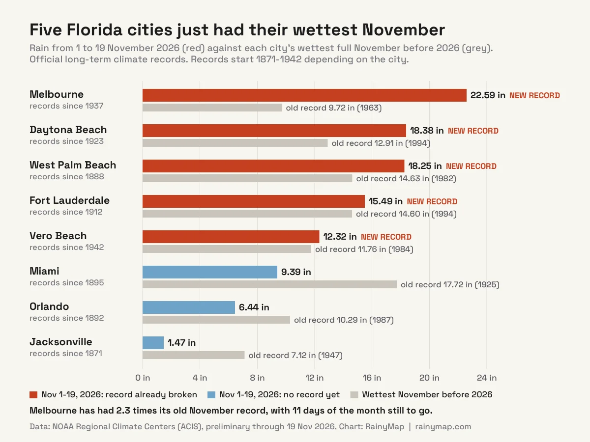
Five of the eight cities we checked have already had their wettest November on record. The table compares rain from 1 to 19 November 2026 with each city’s wettest full November before this year. The figures come from NOAA’s “threaded” city records, which join a city’s old downtown station to its current airport station so the history goes back further.
| City | 1-19 Nov 2026 | Old November record | Normal November | Rank |
|---|---|---|---|---|
| Melbourne | 22.59 in (574 mm) | 9.72 in (1963) | 2.53 in | 1st of 88 |
| Daytona Beach | 18.38 in (467 mm) | 12.91 in (1994) | 2.75 in | 1st of 104 |
| West Palm Beach | 18.25 in (464 mm) | 14.63 in (1982) | 3.60 in | 1st of 138 |
| Fort Lauderdale | 15.49 in (393 mm) | 14.60 in (1994) | 3.78 in | 1st of 112 |
| Vero Beach | 12.32 in (313 mm) | 11.76 in (1984) | 2.91 in | 1st of 84 |
| Miami | 9.39 in (239 mm) | 17.72 in (1925) | 3.52 in | 6th of 129 |
| Orlando | 6.44 in (164 mm) | 10.29 in (1987) | 1.79 in | 5th of 130 |
| Jacksonville | 1.47 in (37 mm) | 7.12 in (1947) | 2.00 in | 87th of 156 |
Normal November = average of 1991-2020 at the same record. Rank counts every November on file, including 2026.
November is normally one of the drier months on Florida’s Atlantic coast, because the wet season ends in mid-October. Miami, one of the rainiest cities in the US by NOAA normals, gets most of its 67 inches a year between June and October. That is why a single wet week in November can break records that a summer week would not.
The rain has also broken autumn records. From 1 September to 19 November, Fort Lauderdale has had 45.85 in (old September-November record 43.47 in, 1924), Melbourne 42.54 in (36.97 in, 2017) and West Palm Beach 41.15 in (39.35 in, 1947).
How Much Rain Fell in Florida This Week?
The second storm hit two areas hardest: Broward County on 17-18 November, then the Volusia and Brevard coasts on 18-19 November. These are the highest totals in the National Weather Service public information statements issued on the afternoon of 19 November.
| Location | County | Rain | Period |
|---|---|---|---|
| 2 SE Plantation (Sewell Locks) | Broward | 17.59 in | Storm total |
| 1 N Dania Beach | Broward | 17.41 in | Storm total |
| 2 W Lauderhill | Broward | 16.23 in | Storm total |
| 1 S Wilbur-by-the-Sea | Volusia | 13.58 in | 72 hours |
| 2 NE The Acreage | Palm Beach | 12.92 in | Storm total |
| Cape Canaveral Space Force Station | Brevard | 12.35 in | 72 hours |
| Daytona Beach International Airport | Volusia | 12.34 in | 72 hours |
| 1 NW Cocoa Beach | Brevard | 11.49 in | 72 hours |
| 1 SW Aventura | Miami-Dade | 9.86 in | Storm total |
On 18 November Melbourne had 2.61 in, more than three times the old daily record for the date (0.71 in, 1959), according to the NWS Melbourne record event report. For readers who think in millimetres, 17 inches is 432 mm. Our guide to what counts as a lot of rain explains the scale.
What Happened in the First Storm on 1-2 November?
The first storm was the more violent one. A slow-moving low over the eastern Gulf of Mexico sent bands of rain over south Brevard County on 1-2 November, and they kept training over the same towns for hours. Preliminary totals reached about 24 inches near Malabar and Grant-Valkaria and about 20 inches in Palm Bay, according to NWS Melbourne figures reported by local media.
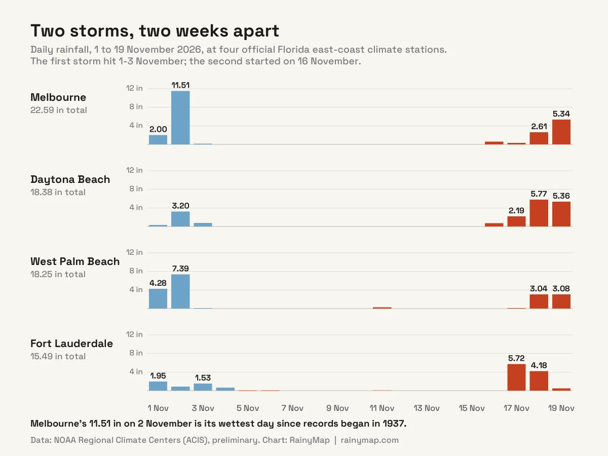
Melbourne’s official station recorded 11.51 in on 2 November. In our check of every day since records began there in 1937, the previous wettest day was 7.04 in on 16 September 1945. NWS Melbourne issued a Flash Flood Emergency, its most severe flash flood warning, for Palm Bay, Melbourne and West Melbourne on the morning of 2 November.
Two men, aged 34 and 78, died in floodwater in Palm Bay. Brevard County deputies and Florida Fish and Wildlife officers carried out about 160 rescues, Insurance Journal reported. An NWS Melbourne meteorologist described the rain as a 1-in-1,000-year event, although no formal return-period analysis has been published yet.
Why Is the St. Johns River Still Rising?
The St. Johns River starts in the marshes west of Melbourne and Vero Beach and flows north, very slowly, for about 310 miles to Jacksonville. The water from the first storm drained into its upper basin and is still there. The second storm added to it.
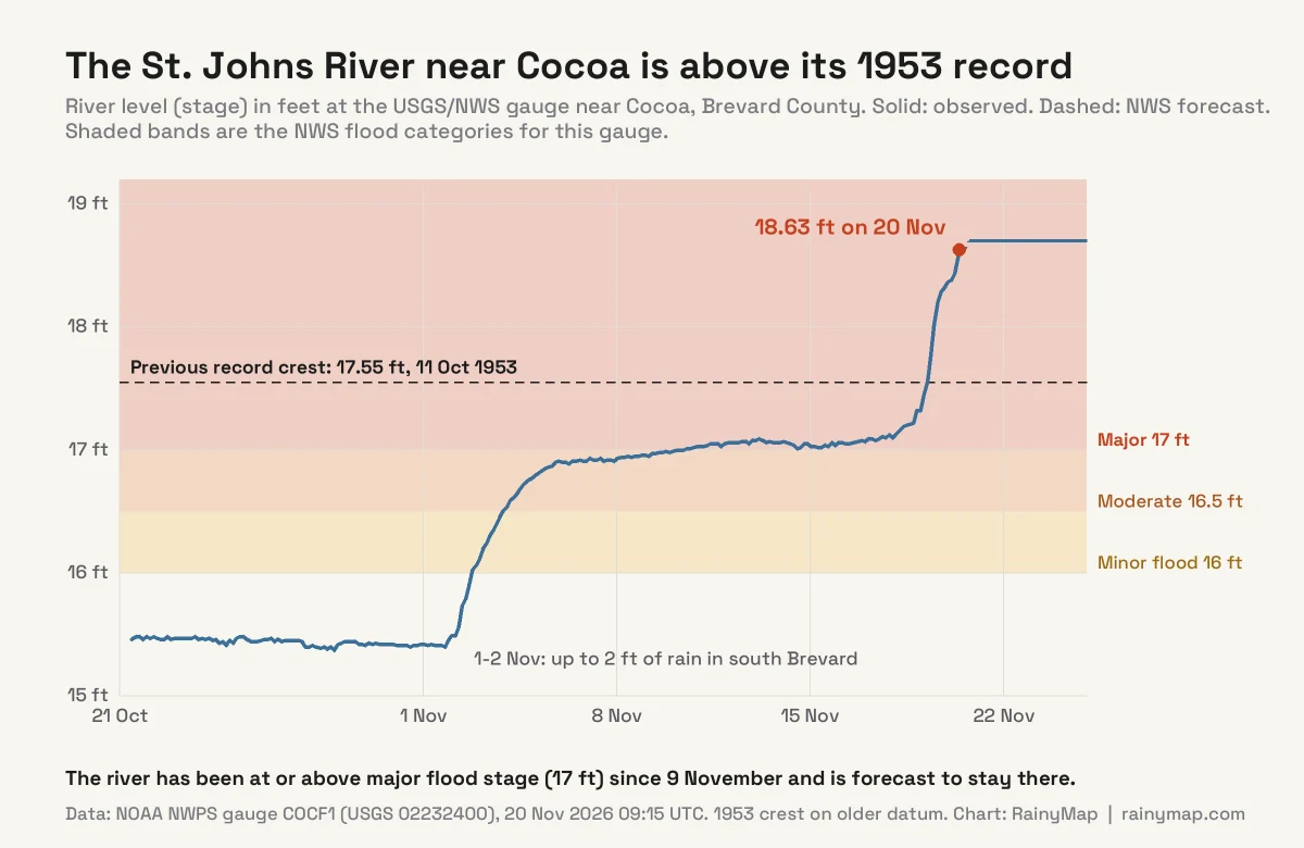
We read the gauge data directly from NOAA’s National Water Prediction Service. The river near Cocoa:
- reached major flood stage (17 ft) on the evening of 9 November and has stayed at or just above it since;
- passed its record crest of 17.55 ft (11 October 1953) at 00:30 EST on 19 November;
- reached 18.63 ft at 04:15 EST on 20 November, more than a foot above the old record;
- is forecast to hold near 18.7 ft through 24 November.
NWS Melbourne warned on 20 November that more heavy rain “is forecast to push river levels higher into the weekend, early next week and beyond.” Because the river is so flat and slow, flooding along it can last for weeks after the rain stops.
Which Florida Counties Are Under a State of Emergency?
Governor Ron DeSantis declared a state of emergency for seven counties on 2 November and expanded it to 14 counties on 3 November. This week he amended it again to cover 21 counties, citing more than 10 inches of rain in 12 hours in parts of Broward County. The order runs through the end of the year.
The 21 counties are: Brevard, Broward, DeSoto, Duval, Flagler, Glades, Hardee, Hendry, Highlands, Indian River, Lake, Martin, Miami-Dade, Monroe, Okeechobee, Palm Beach, Putnam, Seminole, St. Johns, St. Lucie and Volusia.
Will the Low Off Florida Become Subtropical Storm Kyle?
Possibly. At 1 AM EST on 20 November, the National Hurricane Center’s tropical weather outlook said a broad low had formed over southeastern Florida, the northwestern Bahamas and nearby waters. It gave the low a 30% chance of becoming a subtropical or tropical cyclone within 48 hours and 50% within seven days. If it does, it will be named Kyle, the next name on the 2026 Atlantic list.
The name matters less than the effects. The NHC says that whether or not it develops, the system will bring strong winds, dangerous surf, rip currents and coastal flooding to parts of the Southeast and mid-Atlantic coasts into early next week, and more heavy rain to the Florida peninsula today.
Why Is Florida So Wet This November?
Both storms had the same basic set-up: low pressure to the south and high pressure to the north, which drove a long, steady flow of humid air off the Atlantic onto the east coast. NWS Melbourne points to the “long duration of onshore flow”. When the same rain bands come ashore in the same place for two or three days, totals pile up even without a hurricane.
The wider background is the strong El Niño now under way in the Pacific. El Niño strengthens the subtropical jet stream across the Gulf of Mexico in the cool season, and Florida’s winters tend to be wetter during El Niño years. We explain what that means for the coming months in our super El Niño 2026 winter outlook. One wet month cannot be pinned on El Niño alone, but the pattern fits what forecasters expected for this dry season.
What Does a High Risk of Excessive Rainfall Mean?
NOAA’s Weather Prediction Center rates the chance of flash flooding on a four-level scale: Marginal (1), Slight (2), Moderate (3) and High (4). On 20 November, NWS Melbourne said a High Risk, level 4 of 4, covered the Space Coast and Volusia coast, with Slight to Moderate risks further south and inland. High Risk is the top level, used only when widespread, severe and life-threatening flash flooding is expected.
NWS Melbourne expects another 2-4 inches across most of east-central Florida through Saturday and 4-6 inches on the Volusia and Brevard coasts, with a 1-in-10 chance of more than 6-8 inches. The rain is falling on ground that is already saturated. If you live in the warned area, our flash flood safety checklist covers what to do now, and never drive through a flooded road.
How to Track the Rain in Florida Right Now
Rain bands coming off the Atlantic show up on radar as long, narrow lines moving west. When you see the same line sitting over your town for an hour or more, that is the “training” that causes flash flooding. Our guide to flash flood warning signs on radar shows what to look for.
For South Florida, open the Miami live rain radar. For river levels, NOAA’s St. Johns River near Cocoa gauge page updates every 15 minutes and shows the latest forecast.
Frequently Asked Questions
How much rain has Florida had in November 2026?
Through 19 November, Melbourne had 22.59 inches, Daytona Beach 18.38 inches, West Palm Beach 18.25 inches and Fort Lauderdale 15.49 inches, according to NOAA climate records. All four are November records. Individual gauges in Brevard County measured about 24 inches in the first storm alone.
Which Florida city has had the most rain?
Among Florida’s official long-term climate stations, Melbourne has had the most: 22.59 inches from 1 to 19 November 2026, against a normal November of 2.53 inches and an old record of 9.72 inches from 1963. The highest single gauge this week was 17.59 inches near Plantation in Broward County.
Is the St. Johns River at a record level?
Yes, near Cocoa. The river reached 18.63 feet on the morning of 20 November, above the previous record crest of 17.55 feet from 11 October 1953. It has been at or above major flood stage (17 feet) since 9 November and the National Weather Service expects it to stay near 18.7 feet for several days.
How many people have died in the Florida floods?
Two people died in Palm Bay, Brevard County, during the first storm on 2-3 November. No deaths from the second storm (16-20 November) had been reported when we last checked on 20 November.
Is the flooding caused by El Niño?
Not directly. The rain came from two slow storms that pushed Atlantic moisture onto the coast for days. A strong El Niño makes a wet Florida winter more likely by strengthening the subtropical jet stream, so it raises the odds of events like this, but no single storm can be blamed on it.
Will Subtropical Storm Kyle form?
The National Hurricane Center gave the low near southeast Florida a 30% chance of becoming a subtropical or tropical storm within 48 hours and a 50% chance within seven days (outlook issued 1 AM EST, 20 November 2026). If it is named, it will be Kyle.
When will the rain stop in Florida?
NWS Melbourne expects rain chances to fall to 25-50% on Saturday, 21 November, after one more wet day on Friday. River flooding along the St. Johns will continue well after the rain stops.
Which Florida counties are under a state of emergency?
Twenty-one: Brevard, Broward, DeSoto, Duval, Flagler, Glades, Hardee, Hendry, Highlands, Indian River, Lake, Martin, Miami-Dade, Monroe, Okeechobee, Palm Beach, Putnam, Seminole, St. Johns, St. Lucie and Volusia. The order runs until the end of 2026.
Sources
Data checked on 20 November 2026. Monthly, daily and autumn rankings were calculated by RainyMap from NOAA Regional Climate Center (ACIS) threaded station records; river levels were read from the NOAA National Water Prediction Service. All 2026 figures are preliminary.
- NOAA Regional Climate Centers: SC-ACIS station data (Melbourne, Daytona Beach, West Palm Beach, Fort Lauderdale, Vero Beach, Miami, Orlando, Jacksonville)
- NOAA National Water Prediction Service: St. Johns River near Cocoa (COCF1)
- NWS Melbourne: Area Forecast Discussion, 20 Nov 2026
- NWS Melbourne: Public Information Statement, precipitation reports, 19 Nov 2026
- NWS Miami: Public Information Statement, precipitation reports, 19 Nov 2026
- NWS Melbourne: Record Event Report, 19 Nov 2026
- National Hurricane Center: Atlantic Tropical Weather Outlook
- Insurance Journal: state of emergency and deaths in Palm Bay (4 Nov 2026)
- WGCU/FPREN: river flooding after the 1-2 November flash flood (6 Nov 2026)
- Wikipedia: 2026 Election Day floods
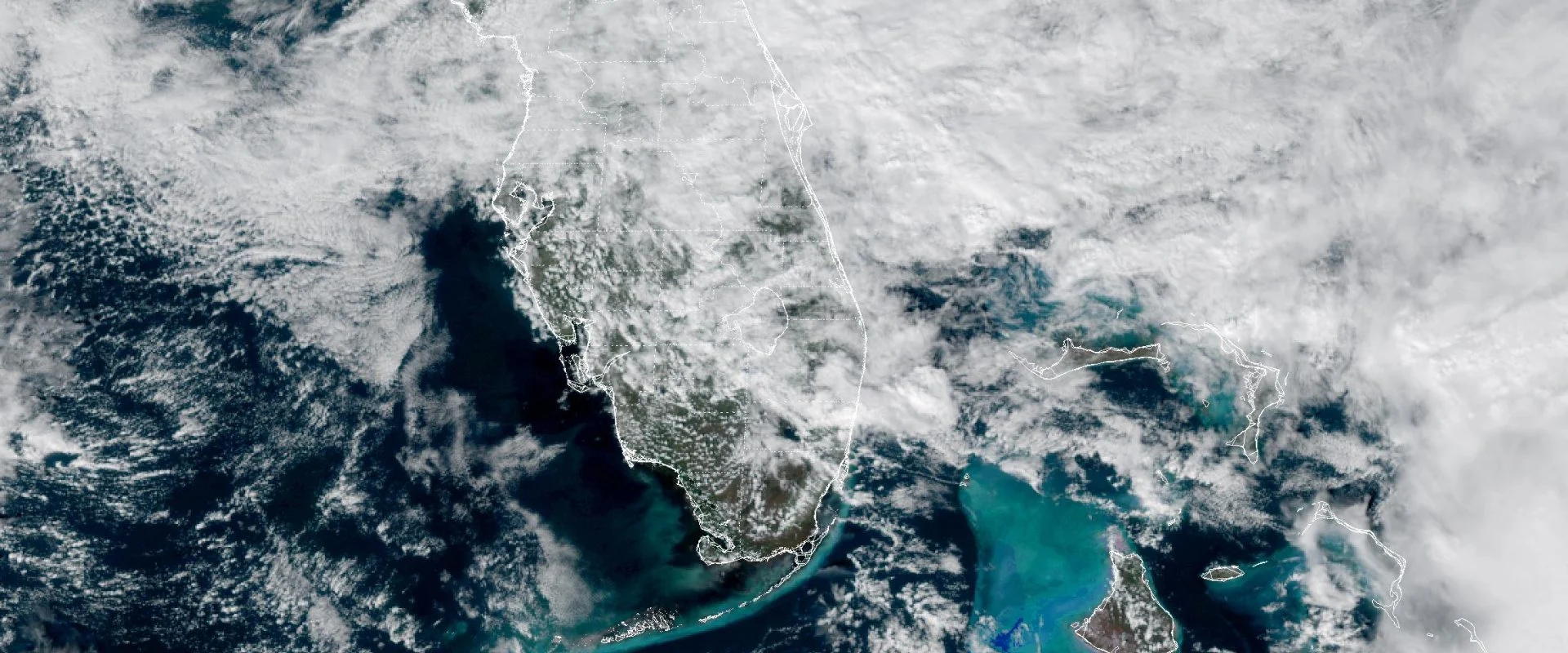
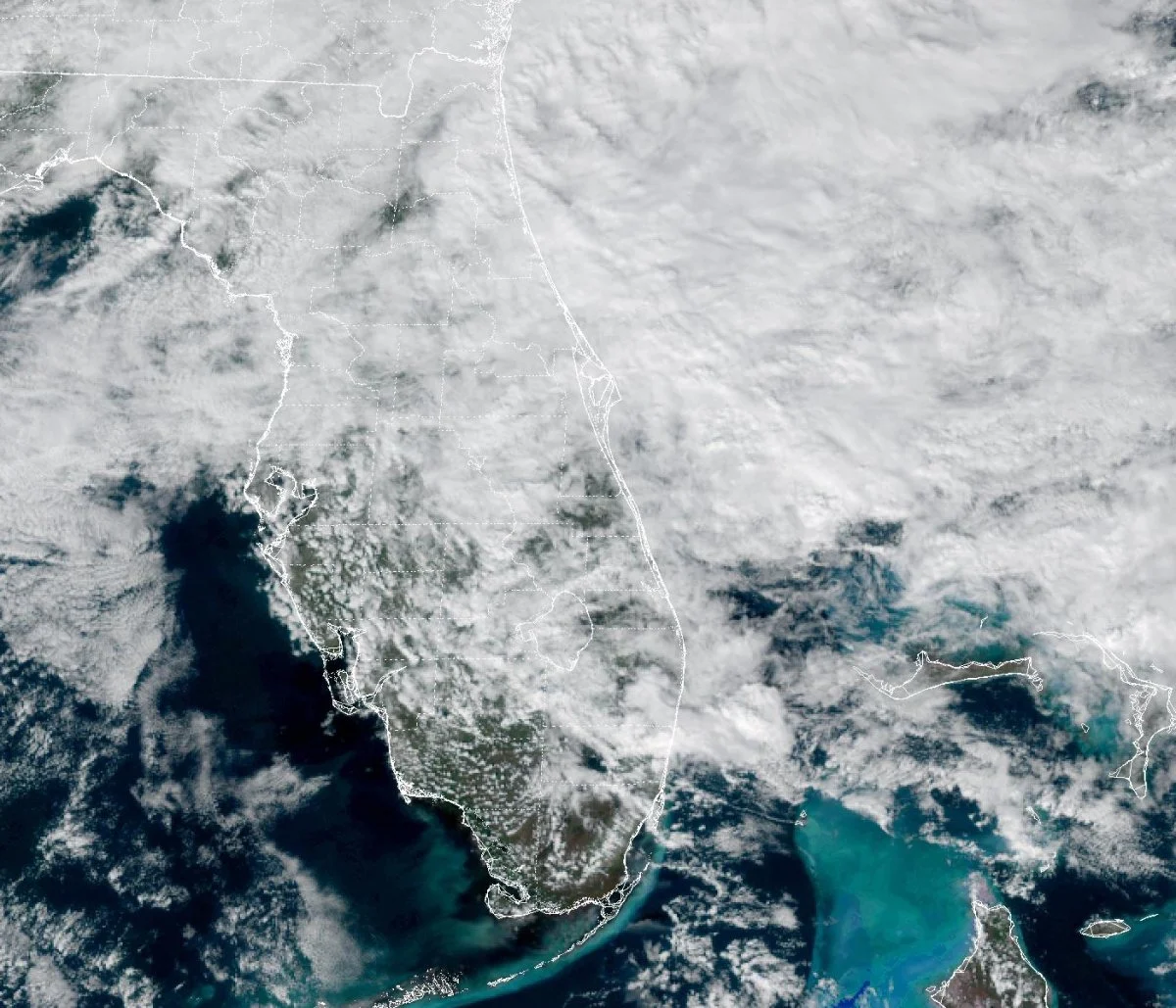
Featured image: Cloud over Florida on 19 November 2026. NOAA/NESDIS/STAR GOES-19 GeoColor (public domain).