Last updated: 14 September 2026. This is a developing story. Casualty figures below are updated to the 12 September count from Nepal’s National Disaster Risk Reduction and Management Authority (NDRRMA). Where an earlier figure from 28 August is kept, it is marked as such, so the record of what was known when stays visible.
Update, 12 September: The confirmed death toll in Nepal has risen from 389 at the time of first publication to 1,386, with 5,130 people still missing. In Tibet, Xinhua reported 43 dead and 519 missing. More than 900 workers at 12 hydropower projects are among the missing, around 500 of them believed trapped in tunnels. Nepal observed a national day of mourning on 7 September. Only 104 of the recovered bodies had been identified by 12 September.
Quick Answer
The disaster that has killed at least 1,386 people in Nepal since 26 August 2026 was not a monsoon flood. It was triggered by a glacier collapse. A section of ice roughly 610 metres wide broke away on Langtang Lirung, near the Nepal–Tibet border, and fell about 1,200 metres. The impact registered as a magnitude 5.2 seismic event on instruments around the world. The resulting wall of water, ice and rock travelled the first 22 kilometres at an average of 193 km/h — covering that distance in 6 minutes and 50 seconds. As of 12 September, Nepal’s disaster authority had confirmed 1,386 deaths, with 5,130 people still missing. In Tibet, 43 people died and 519 were missing, according to Xinhua.
What Actually Happened
At 02:52 UTC on 26 August (08:37 Nepal time), seismometers picked up a signal from the Himalaya. It was initially logged as a magnitude 4.4 earthquake. Analysis of the long-period seismic waves showed it was something else: not a rupture along a fault, but a very large mass falling. USGS subsequently confirmed the signature was consistent with a glacier collapse rather than an earthquake.
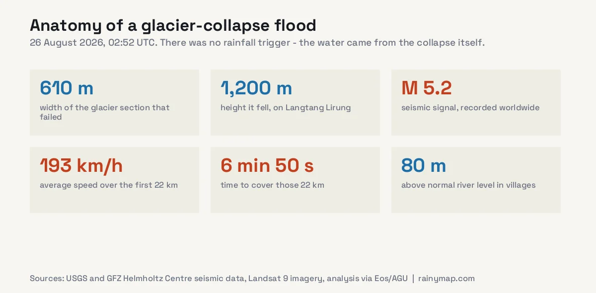
This distinction matters more than it might appear. Nepal is in monsoon season, and most flood coverage from the region in August concerns rainfall. This event had no rainfall trigger. The water was generated by the collapse itself, from three sources: ice flash-melted by the sheer energy released on impact, water squeezed out of the saturated sediment the mass picked up as it travelled, and the river already in the valley.
That is why there was effectively no warning. A monsoon flood builds over hours as rain accumulates in a catchment, and river gauges upstream give downstream communities time. A collapse-driven flood arrives as a wave. Landsat 9 has since captured before-and-after imagery of the scar on the mountain.
The scale of the surge is difficult to picture. Seven kilometres from the origin, water ran up to 800 metres up the valley sides. In inhabited areas further down, it reached roughly 80 metres above normal river level. Debris was carried around 80 kilometres downstream along a devastated stretch of roughly 72 kilometres.
Where the Dead Have Been Recovered
The geographic pattern in the recovery data is striking. The collapse happened in Rasuwa district, on the border, yet most of the dead have been recovered far downstream.
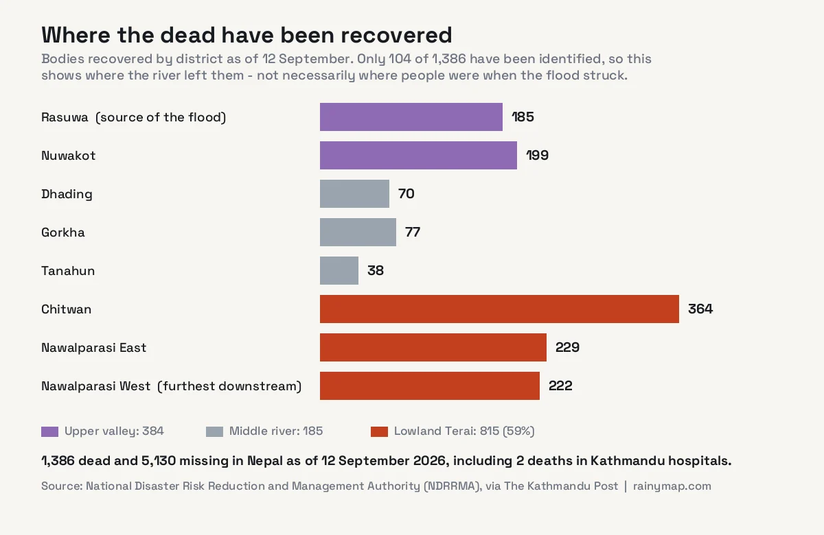
As of 12 September, Chitwan had recorded 364 recovered bodies, Nawalparasi East 229 and Nawalparasi West 222 — together 815, or 59% of all confirmed deaths. Rasuwa, where the flood began, had 185 and Nuwakot 199. The upper valley’s share has grown as search teams reached it: on 28 August, Rasuwa and Nuwakot accounted for 45 of 389 deaths (12%); by 12 September they accounted for 384 of 1,386 (28%).
A correction to our original analysis. When we first published on 28 August, we attributed the downstream concentration mainly to population geography: the lowland districts are flatter and far more densely settled than the steep upper valley. That remains part of the picture, but the updated figures show it was incomplete.
A recovered body is recorded in the district where it is found, and a river in flood carries the dead a very long way. By 12 September only 104 of the 1,386 bodies had been identified. The district totals therefore describe where the Trishuli deposited victims at least as much as where people were when the flood struck. The 5,130 still missing point the other way: they include hundreds of hydropower workers and trekkers who were in the upper valley when the wave came through.
This is the single most transferable lesson from the event. In mountain hazard planning, attention naturally concentrates on communities directly beneath a glacier or unstable slope. But a river is a delivery system. A failure high in the Himalaya is a threat to people who cannot see the mountain it happened on.
Who Is Missing
As of 12 September, 5,130 people were still missing in Nepal and 519 in Tibet. The composition of that figure reflects what this border corridor is used for. Some figures below date from 28 August and are marked as such.
- Trekkers and travellers. As of 28 August, 668 from 34 countries were reported missing. The largest national groups were India (177), the United States (90), Australia (34), the United Kingdom (33) and Canada (25), with around 100 Chinese nationals. By 1 September, around 747 people were thought missing in Rasuwa alone, including roughly 583 tourists, according to Nepal’s tourism board.
- Pilgrims travelling the route towards Mount Kailash and Lake Mansarovar, for whom this crossing is a main access corridor.
- Hydropower workers. More than 900 people at 12 hydropower projects were reported missing, around 500 of them believed trapped in tunnels. Survivors were still being brought out of tunnels more than a week after the flood.
- 85 security personnel — 44 from the Nepali Army, 28 from Nepal Police and 13 from the Armed Police Force.
- On the Chinese side, Xinhua reported 43 dead and 519 missing at Gyirong, including 261 foreign nationals from 23 countries. In the first days, authorities there had reported 3 dead and 558 missing.
As of 12 September, 3,761 people were sheltering in 37 holding centres — 2,587 in Nuwakot, 839 in Rasuwa and 335 in Dhading. Rasuwa district has a population of roughly 50,000.
Rescue Is Being Fought Uphill
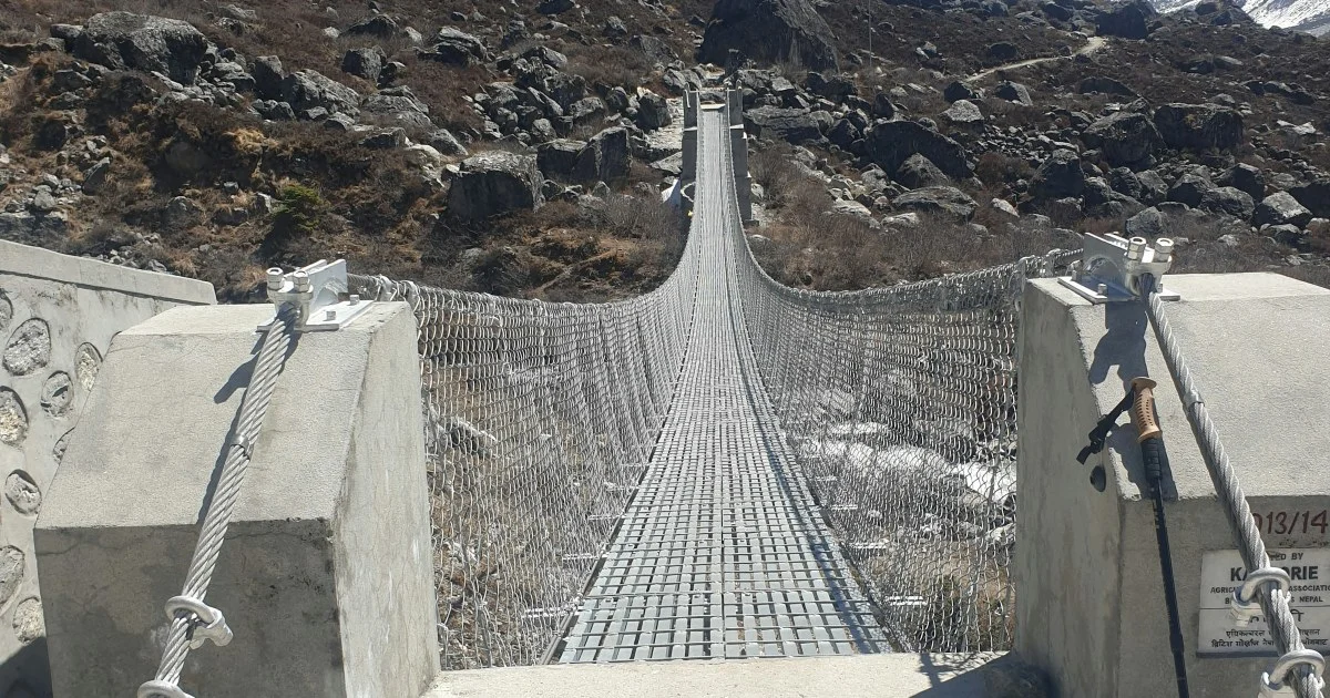
The same terrain that channelled the flood is now obstructing the response. At Syapru Besi and Timure — two of the worst-affected settlements — water levels were too high for rescue helicopters to land. Roads into the upper valley were among the first things destroyed. On the Chinese side, deep sediment deposits have blocked rescue teams from reaching parts of the affected zone.
Nepal deployed the Army, Nepal Police and Armed Police Force alongside helicopters. By 12 September, 13,728 people had been rescued and 339 were being treated in 19 hospitals. There is also a continuing concern that further landslides or a secondary flood could occur in a valley now full of unstable, freshly deposited debris.
A Fifth of Nepal’s Power Went With It
Beyond the human toll, the flood struck one of the densest concentrations of hydropower infrastructure in Nepal, because the same steep, fast-flowing rivers that make a valley dangerous also make it valuable for generation.
- Six major hydropower facilities damaged: Rasuwagadhi, Chilime, Trishuli 3A, Trishuli 3B, the main Trishuli station and Devighat.
- 431 megawatts removed from the national grid, with a further 470 MW of under-construction capacity damaged.
- 41 bridges destroyed or damaged, along with 42 km of road and 20 schools across Rasuwa, Nuwakot and Dhading.
- Initial damage estimates exceed Rs 15 billion.
- On the Chinese side, Gyirong Port was reported completely destroyed, with more than 300 vehicles swept away at the customs site.
For a country that relies overwhelmingly on hydropower, losing 431 MW at once is a second-order disaster that will outlast the immediate emergency. Nepal’s Prime Minister Balen Shah travelled to Nuwakot on 27 August to assess the situation. China’s Xi Jinping called for continued search efforts and improvements to disaster monitoring, and Sri Lanka’s President Anura Kumara Dissanayake pledged US$1 million in humanitarian assistance.
Why Himalayan Ice Is Failing
Attribution for any single event requires caution, but the climate link here is better supported than for many weather disasters. Research on the Langtang glaciers specifically documents rapid warming and accelerating recession. Dave Petley, the landslide scientist who writes for AGU’s Eos and is among the most-cited voices on slope failures, is among those pointing to warming ice as a contributing factor.
The mechanism is reasonably well understood. High-mountain ice and rock are often held together by permafrost — ground that stays frozen year-round. As mean temperatures rise, that frozen bond thaws at progressively higher elevations. Meltwater then penetrates fractures that were previously sealed by ice, reducing friction and adding pressure. Slopes that were stable for centuries because they were frozen become slopes that are stable only until they are not.
This is the same physical story unfolding at the other end of the planet, where Arctic ice older than four years has collapsed by 95% since the 1980s, and it sits inside a year already tracking among the warmest ever measured — see our hottest-year tracker for that context.
What cannot honestly be said is that warming caused this specific block of ice to fall on this specific morning. Glacier collapses occurred before industrial warming. What can be said is that the conditions which make them more likely are increasing, in a range where hundreds of thousands of people live downstream of frozen slopes.
Why This Kind of Flood Is So Hard to Warn For
Conventional flood warning depends on watching rainfall and river levels rise. Neither helps here. There is no rain to measure, and by the time a gauge upstream registers the surge, the wave is minutes away rather than hours.
What does work, partially, is seismic detection. This collapse was recorded worldwide within seconds — the signal existed long before the water reached Chitwan. The obstacle is not detection but interpretation and dissemination, and the timeline of 26 August shows exactly where it broke down.
The 38 minutes
According to reporting by The Kathmandu Post, the glacier gave way at 8:37am. By 8:50am the flood had swept away the river gauge at the Syabrubesi hydrological station. At 9:00am, Rasuwa’s district administration informed the Department of Hydrology and Meteorology. Text alerts went out to residents of Rasuwa, Nuwakot, Dhading and Chitwan at 9:15am — 38 minutes after the collapse, by which time the first 22 kilometres of valley had been overrun for half an hour.
Each link in the chain had a reason. The chief of Nepal’s National Earthquake Monitoring and Research Center said the seismic signal did not match the frequency of an earthquake, so no public alert was issued. The hydrology department said the Syabrubesi gauge was designed to detect gradual rises in river level, not a high-speed surge. And an NDRRMA geologist said there is no formal protocol for cross-border flood information from the Chinese side. A former head of the disaster authority put it more bluntly: Nepal does not have an early warning system, only parts of one.
What worked instead
Some of the most effective warnings came from people, not systems. At Tribhuvan Trishuli Secondary School in Nuwakot, head teacher Rajendra Dawadi received frantic phone calls from contacts upstream and ordered students to higher ground immediately. Roughly 900 students were evacuated with about ten minutes to spare, according to Mongabay. In Chitwan, a volunteer watch system in place since 2002 — an observer on a raised platform who sends a runner door to door when the water rises — relies on the same principle: a trusted, named person saying the water is coming.
Official text alerts, by contrast, were criticised for lacking exact locations, severity and clear instructions. The lesson is not that technology failed and people succeeded, but that detection without a fast, trusted route to the people downstream is not a warning.
Some Himalayan valleys have glacial lake outburst warning systems. This was not a lake outburst, which is a reminder that hazard systems designed for one failure mode do not necessarily catch another.
Monsoon Season Is Not Over
Nepal’s monsoon typically runs into late September. Rain falling now lands on catchments already stripped of vegetation and loaded with fresh, unconsolidated debris, which raises the risk of secondary landslides and further flooding in the same valleys. Anyone travelling in or near the affected districts should follow the guidance of Nepali authorities rather than making independent judgements about access.
For live conditions, our real-time rain map shows where precipitation is currently falling across the Himalaya, the Kathmandu radar page covers the Bagmati region, and the 7-day forecast gives the week ahead. For broader seasonal context on when the monsoon arrives and clears, see our guide to the best time to visit Nepal.
Frequently Asked Questions
What caused the Nepal flood in August 2026?
A glacier collapse, not rainfall. A section of ice roughly 610 metres wide broke away on Langtang Lirung near the Nepal-Tibet border on 26 August 2026 and fell about 1,200 metres. The impact generated a magnitude 5.2 seismic signal and produced a flood wave from flash-melted ice, water in entrained sediment and the river itself.
How many people died in the Nepal flood?
As of 12 September 2026, Nepal’s National Disaster Risk Reduction and Management Authority confirmed 1,386 deaths, with 5,130 people still missing and 13,728 rescued. In Tibet, Xinhua reported 43 dead and 519 missing. When this article was first published on 28 August, the confirmed toll was 389; it rose sharply as search teams reached cut-off areas and recovered bodies downstream.
Why have most bodies been found far from the glacier?
Partly because the flood travelled down the Trishuli into densely populated lowlands, and partly because a river in flood carries victims a long way before they are found. As of 12 September, Chitwan had recorded 364 recovered bodies and the two Nawalparasi districts 451, against 185 in Rasuwa where the collapse occurred. Only 104 bodies had been identified, so district totals show where the dead were recovered rather than where they were when the flood struck.
How fast was the flood wave?
The wave covered the first 22 kilometres at an average speed of 193 km/h, taking 6 minutes and 50 seconds. Seven kilometres from the origin it ran up to 800 metres up the valley sides, and in inhabited areas downstream it reached around 80 metres above normal river level.
Were tourists and trekkers affected?
Yes. As of 28 August, 668 trekkers and travellers from 34 countries were reported missing in Nepal, with the largest groups from India (177), the United States (90), Australia (34), the United Kingdom (33) and Canada (25). In Tibet, Xinhua reported 261 foreign nationals from 23 countries among the missing. Pilgrims travelling towards Mount Kailash and Lake Mansarovar were also caught, as the affected crossing is a main access route.
Was this caused by climate change?
Warming is considered a contributing factor rather than a proven direct cause. Research on the Langtang glaciers documents rapid warming and accelerating recession, and thawing high-altitude permafrost reduces the frozen bond holding ice and rock to steep slopes. No single collapse can be attributed to climate change with certainty, but the conditions that make such failures more likely are increasing.
Could this have been forecast?
Not by conventional flood forecasting, which relies on measuring rainfall and rising river levels. There was no rain involved and the wave moved too fast for gauge-based warning. The collapse was detected seismically within seconds, but the signal did not match an earthquake and no public alert followed. Text alerts reached four districts at 9:15am, 38 minutes after the collapse. Some communities were warned faster by phone calls from people upstream.
Sources
- Al Jazeera — Nepal-Tibet floods: what happened, what caused them and who is missing
- EarthSky — Nepal flash flood: glacier collapse and landslide, 26 August 2026
- OnlineKhabar — Rasuwa flood death toll reaches 389 across eight districts (28 August)
- The Kathmandu Post — August flood death toll rises to 1,386, with 5,130 still missing (12 September)
- The Kathmandu Post — Nepal sent its disaster alert 38 minutes after the glacier collapse (2 September)
- Mongabay — During Nepal floods, community-based warning saved lives (3 September)
- Al Jazeera — Nepal holds day of mourning (7 September)
- New Straits Times / Xinhua — 43 dead, 519 missing at Gyirong Port
- myRepublica — Death toll climbs as rescue efforts continue
- CNN — Deadly flash flood hits Nepal-China border region
- 2026 Nepal floods — consolidated figures and infrastructure damage