Last updated: 14 September 2026. Data: Copernicus Climate Change Service (C3S), released 10 September 2026.
Quick Answer
August 2026 was the joint-hottest month ever recorded on Earth. The global average surface air temperature reached 16.96°C, which is 1.65°C above pre-industrial levels (1850–1900) and 0.85°C above the 1991–2020 average, according to the Copernicus Climate Change Service. It ties July 2023 for the warmest month in the record and is outright the warmest August. It is also the first month above the 1.5°C mark since November 2025. The June–August period tied 2024 as the warmest northern summer on record, and ocean surface temperatures outside the polar regions hit a record 21.07°C. A strong El Niño, forecast to intensify further, is the main short-term driver on top of long-term warming.
The Numbers
- Global surface air temperature: 16.96°C — joint-warmest month on record, tied with July 2023
- Above pre-industrial (1850–1900): +1.65°C
- Above the 1991–2020 average: +0.85°C
- June–August 2026: joint-warmest on record globally, on par with 2024
- Sea surface temperature (60°S–60°N): 21.07°C — highest August on record, and tied with March 2024 as the highest of any month
- European land in August: 20.26°C, +1.10°C above average — fourth-warmest August
- Western Europe: warmest summer on record, beating 2003
- Sea ice: Arctic 12th lowest for August; Antarctic 4th lowest
Samantha Burgess, Strategic Lead for Climate at ECMWF, described it as “a remarkable month in the global climate record.”
Why “Joint” Hottest and Not Outright
The previous record holder, July 2023, came in at 16.95°C. August 2026 is 16.96°C — a difference of one hundredth of a degree. That is inside the uncertainty of any global temperature estimate, so Copernicus reports the two as tied rather than declaring a new record.
That is the honest way to read it. Nobody can meaningfully say which of the two months was warmer. What can be said is that the planet has now reached the same peak twice in three years, and that the second time it did so in August rather than July.
Seven Months Just Below 1.5°C, Then a Jump
The most striking thing about August is not the number itself but how abruptly it arrived. Every month of 2026 before it sat just under the 1.5°C line.
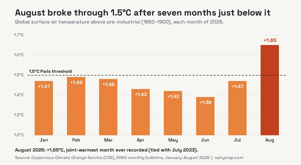
January through July ranged between 1.39°C and 1.49°C above pre-industrial. February came within a hundredth of a degree of the threshold. Then August leapt to 1.65°C — a rise of 0.18°C in a single month, and 0.26°C above June.
Monthly figures always bounce around, but a jump of that size is unusual, and the second view of the same data shows why it is not noise.
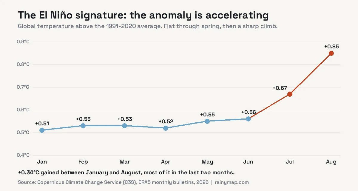
Measured against the 1991–2020 average, 2026 was remarkably flat through the first half of the year, hovering between +0.51°C and +0.56°C. From June the line turns sharply upward: +0.67°C in July and +0.85°C in August. That is the shape of an El Niño taking hold.
Why August Was So Hot: El Niño on Top of the Trend
Two things are stacked here, and it matters to keep them separate.
The long-term trend is the floor. Human-driven warming has lifted global temperatures steadily for decades, which is why even an ordinary 2026 month sits near 1.4–1.5°C above pre-industrial. That part does not fluctuate month to month.
El Niño is the surge on top. Copernicus reports strong El Niño conditions across the tropical Pacific, with forecasts suggesting it could intensify into one of the strongest events on record. During El Niño, the ocean releases large amounts of stored heat into the atmosphere, temporarily lifting global temperatures. Our El Niño and La Niña explainer covers the mechanism in detail.
There is an important timing detail. Global temperatures typically peak a few months after El Niño itself peaks, because the heat takes time to spread through the atmosphere. That lag is why the annual records of 2016 and 2024 came in the years following the big El Niño events rather than during them. If this El Niño keeps strengthening, the warmest part of the cycle may still be ahead.
The Oceans Set a Record of Their Own
The average sea surface temperature between 60°S and 60°N — the world’s oceans outside the polar regions — reached 21.07°C in August. That is the highest August on record and ties March 2024 as the highest value for any month in the dataset. On individual days it climbed as high as 21.11°C.
The ocean is where the story really lives. It absorbs the overwhelming majority of the extra heat trapped by greenhouse gases, and it releases that heat slowly. A record-warm ocean surface does not cool off when the calendar turns to September; it feeds the atmosphere for months, fuels heavier rainfall where storms do form, and supplies the energy that makes marine heatwaves and intense tropical systems more likely.
It is also a reminder that the record it matched was set in March 2024, during the last El Niño’s influence. Reaching the same level in August, with El Niño still building, is a meaningful signal.
Europe: A Record Summer in the West, Rivers Running Dry
Europe tells a more nuanced story than the global headline. August on its own was only the fourth-warmest August for European land, at 20.26°C. Across the whole summer, Europe as a continent ranked third-warmest, behind 2024 and 2022.
But the distribution was lopsided. Western Europe had its warmest summer on record, beating 2003 — the summer long used as the benchmark for European heat, when heat-related deaths ran into the tens of thousands.

The heat came with persistent dryness. Copernicus reports exceptionally low flows on the Rhine, Danube, Southern Bug and Dnieper, with severe drought in France, the UK, Hungary, Romania and Serbia. Drier-than-average conditions covered western and central Europe, southern Scandinavia and south-eastern Europe. We covered the scale of it in Europe’s 2026 drought, with the Rhine at its lowest level since 1880.
Not everywhere was dry. Western Iberia, the Alpine region, north-eastern Europe and eastern Türkiye were wetter than average — which is typical of a stuck summer pattern, where the same regions stay under high pressure while storm tracks are diverted around them.
The Rest of the World
Beyond Europe, August was drier than average across the southern United States and northern Mexico, the Maghreb, the Horn of Africa, Siberia, central Asia, China, and parts of South America, southern Africa and northern Australia.
It was wetter than average in the eastern United States and Canada, Alaska, the northern Indian subcontinent, Chile, south-eastern Brazil and eastern Asia.
Sea ice stayed low at both poles: the Arctic ranked 12th lowest for August and the Antarctic 4th lowest. The Arctic figure is less extreme than the long-term decline might suggest, but as we explained in our piece on Arctic sea ice in 2026, extent is the least revealing measure — the thick, old ice that once anchored the pack has almost entirely gone.
Does One Month Above 1.5°C Mean the Paris Limit Is Broken?
No — and this is the most commonly misunderstood point in coverage like this.
The 1.5°C goal in the Paris Agreement refers to long-term warming, usually assessed as an average over around 20 years. A single month, or even a single year, above 1.5°C does not mean the limit has been breached. Individual months swing up and down with El Niño, volcanic eruptions and ordinary variability.
What a month like August does show is how thin the margin has become. For most of 2026 the ordinary months were already at 1.39–1.49°C. It takes only a moderate natural push — one El Niño — to tip the planet over the line. When the underlying average sits that close to the threshold, the long-term breach stops being a distant projection and becomes a question of a few years.
Is 2026 Going to Be the Hottest Year on Record?
It is now a serious contender. The first half of the year ranked high but not at record level — January was only the fifth-warmest January, and no month from January to June set a monthly record. August changes that picture, and with El Niño strengthening and global temperatures typically lagging it, the final months of 2026 could run very warm.
Because El Niño’s global effect tends to arrive with a delay, there is also a strong case that 2027 could be warmer still. We track the running picture month by month in Is 2026 going to be the hottest year ever recorded?
What This Means Day to Day
Global averages can feel abstract. In practice a hotter atmosphere and ocean show up locally as more frequent and intense heatwaves, faster drying of soils between rain events, and heavier downpours when rain does come, because warmer air holds more moisture. The summer’s second US heat dome and Europe’s drought are both part of the same picture.
To see what the weather is doing where you are right now, use the live temperature map, the live rain map, and the 7-day forecast.
Frequently Asked Questions
Was August 2026 the hottest month ever recorded?
It was the joint-hottest. The Copernicus Climate Change Service measured a global average surface air temperature of 16.96°C, tying July 2023 (16.95°C) for the warmest month on record. The difference is within measurement uncertainty, so the two are reported as tied. It was outright the warmest August on record.
How much warmer than pre-industrial was August 2026?
August 2026 was 1.65°C above the 1850–1900 pre-industrial average and 0.85°C above the 1991–2020 average. It was the first month above 1.5°C since November 2025.
Does a month above 1.5°C mean the Paris Agreement limit has been broken?
No. The Paris 1.5°C goal refers to long-term warming averaged over around 20 years. Individual months and years fluctuate with El Niño and natural variability. A month above 1.5°C shows how little margin remains, but it is not a breach of the long-term limit.
Why was August 2026 so hot?
Long-term human-driven warming provides the baseline, and a strong El Niño in the tropical Pacific added a temporary surge by releasing stored ocean heat into the atmosphere. Global temperature rose from 0.56°C above the 1991–2020 average in June to 0.85°C in August.
How warm were the oceans in August 2026?
The average sea surface temperature between 60°S and 60°N reached 21.07°C, the highest August on record and tied with March 2024 as the highest value for any month. Daily values reached 21.11°C.
How hot was Europe in August 2026?
European land averaged 20.26°C in August, 1.10°C above average and the fourth-warmest August on record. Europe’s summer overall was the third-warmest, while Western Europe had its warmest summer on record, beating 2003. Rivers including the Rhine and Danube ran exceptionally low.
Will 2026 be the hottest year on record?
It is a serious contender after August. With El Niño forecast to strengthen and global temperatures typically peaking a few months after El Niño itself, the remaining months of 2026 could be very warm, and 2027 could be warmer still.
Where does this temperature data come from?
From the Copernicus Climate Change Service, implemented by ECMWF for the European Union. Its monthly bulletins are based on the ERA5 reanalysis, which combines vast numbers of observations from satellites, ships, aircraft and weather stations with a weather model to produce a consistent global record.
Sources
- Copernicus — August was the world’s joint-hottest month on record, pushing global temperatures back above 1.5°C (10 September 2026)
- Copernicus — Surface air temperature for July 2026
- Copernicus — Surface air temperature for June 2026
- Copernicus Climate Change Service — monthly climate bulletins, January–August 2026