Last updated: August 25, 2026.
Quick Answer
A tornado tore through the village of Pomas in the Aude, about 12 km south of Carcassonne, just after 5pm on Monday 24 August 2026, injuring 41 people and damaging around 300 homes in a commune of roughly 1,000 inhabitants. Fifteen people were hospitalised, including a pregnant woman hurt when her house collapsed on her. No deaths have been reported. But the tornado was only one part of the story: KERAUNOS, France’s tornado and severe storm observatory, has confirmed that the parent storm system met the criteria for a derecho — a single, long-lived windstorm that swept roughly 550 km across southern France in about eight hours, from the Aude to Corsica, with gusts up to 135 km/h.
What Happened at Pomas
The tornado touched down at around 17:05 local time (15:05 UTC) near Pomas, in the Aude valley south of Carcassonne. It crossed part of the village and the surrounding farmland, tearing roofs off houses, uprooting large numbers of trees and overturning vehicles.
- 41 injured, 15 taken to hospital. No fatalities.
- About 300 homes damaged in a village of roughly 1,000 people.
- 2,800 households lost power across more than ten communes.
- Over 120 emergency personnel deployed, with an operational command centre opened at the Aude prefecture and two shelters set up in Pomas.
- Hail up to about 5 cm fell near the tornado track.
KERAUNOS has opened a field investigation to establish the tornado’s exact track and intensity. Their preliminary assessment, based on the damage reported so far, is that it was probably EF2 or EF3 on the Enhanced Fujita scale — which would make it a strong tornado by any standard, not merely a European curiosity. That rating is provisional until the survey is complete.
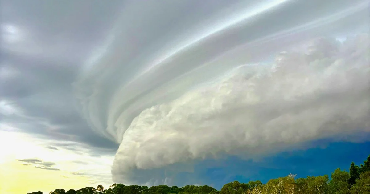
Radar data explains why it was capable of that. The storm was a textbook supercell, and imagery showed a hook echo on its southern flank together with a tightly compressed velocity dipole — the classic radar signature of intense, concentrated rotation in a mesocyclone. This was not a brief spin-up along a squall line. It was a rotating thunderstorm doing exactly what rotating thunderstorms do.
The Bigger Story: This Was a Derecho
Most coverage of 24 August has focused on the tornado, because a tornado hitting a French village is dramatic and photogenic. But the tornado was a small, brief feature embedded in something much larger.
KERAUNOS assessed the wider storm complex and concluded that the criteria for a derecho were met. A derecho is not a type of storm cloud — it is a classification based on outcome. It describes a swathe of damaging straight-line winds produced by a fast-moving line of thunderstorms that sustains itself over a long distance rather than dying out after an hour or two.
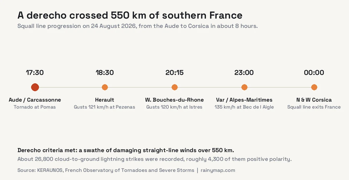
The line moved with remarkable consistency. It struck the Aude and Carcassonne area around 17:30, reached the Hérault by roughly 18:30, western Bouches-du-Rhône by 20:15, the Var and Alpes-Maritimes after 23:00, and northern and western Corsica around midnight. That is roughly 550 km in eight hours — an average forward speed of close to 70 km/h, maintained across an entire evening.
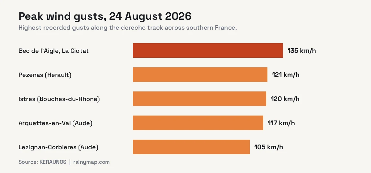
Gusts along the corridor generally ran between 90 and 130 km/h, with the strongest reading of 135 km/h at Bec de l’Aigle near La Ciotat. Météo-France had placed 22 departments on orange alert for storms. The electrical activity was equally striking: roughly 26,800 cloud-to-ground lightning strikes were recorded, of which about 4,300 were positive-polarity — the rarer, typically more energetic kind. Storm tops punched to around -75°C, a marker of extremely deep, vigorous convection.
Why a Derecho Matters More Than a Tornado
This distinction is not pedantry. A tornado is intensely destructive but geographically tiny — a track typically a few hundred metres wide and a few kilometres long. Pomas was unlucky in a very specific, narrow way.
A derecho is the opposite: individually less violent at any single point, but affecting a corridor hundreds of kilometres long and tens of kilometres wide. That is why the same system that flattened part of one village also disrupted transport across the whole south of France, with train delays, road closures and flight cancellations reported at Bordeaux, Marseille, Nice, Toulouse and Paris.
For anyone assessing risk — insurers, grid operators, emergency services — the derecho is the more consequential event, even though the tornado generates the photographs.
The Vuelta a España Stage That Never Finished
The storm also produced one of the more unusual sporting scenes of the year. Stage 3 of the 2026 Vuelta a España — a 174 km route from Gruissan in the Aude to Font-Romeu in the Pyrenees — ran directly into the developing system.
With roughly 15 km left to race, the peloton was hit by a violent hailstorm. Race leader Tadej Pogačar signalled to the other riders to stop. Organisers subsequently cancelled the stage outright: no winner was declared and no times were recorded. It was the first abandoned stage of the 2026 edition.
Hail of the size reported nearby — around 5 cm, roughly a golf ball — striking unprotected cyclists at racing speed is a genuine injury risk, not an inconvenience. The decision to stop was straightforward.
How Rare Is This for the Aude?
Rare, but far from unprecedented — and the historical record is the most interesting context available.
KERAUNOS maintains a catalogue of French tornadoes stretching back to 1776. In that entire archive, the Aude department has just 17 documented tornadoes. The most destructive remains the EF4 tornado at La Redorte on 13 August 1887, which killed eight people. The most recent before this week was an EF0 at Gruissan on 15 October 2018 — the weakest category on the scale, and a very different event from what hit Pomas.
Nationally the picture is different again. Météo-France notes that France records several dozen tornadoes in an average year. Most are weak, brief, and occur over farmland or coastline where they damage little and are reported barely at all. France is, in fact, one of the more tornado-prone countries in Europe. What made 24 August exceptional was not that a tornado formed, but that a strong one crossed a populated village.
It Was Forecast
A detail worth highlighting, because it rarely survives into general coverage: this was anticipated. In its bulletin published that morning, KERAUNOS had flagged a tornado risk of level 3 out of 4 for the region, based on the combination of strong instability and strong vertical wind shear — the two ingredients that allow a thunderstorm to organise into a rotating supercell rather than a disorganised downpour.
Météo-France’s orange alert across 22 departments carried the same message through official channels. The atmosphere behaved as forecast. Severe convective forecasting cannot tell you which village will be hit — that remains beyond the science — but it identified the day and the region correctly, hours ahead.
Is This Climate Change?
The honest answer is that nobody can currently say, and the most authoritative voice in the story says so explicitly.
Météo-France stated directly that the connection between global warming and tornado frequency remains unclear. That caution is well founded. Tornado records are heavily distorted by observation bias — today every phone is a camera and every event reaches social media within minutes, so apparent increases in frequency may largely reflect better detection rather than more tornadoes. Tornadoes are also small and short-lived, which makes them extremely difficult to model or attribute compared with heatwaves or heavy rainfall.
What can be said with more confidence is narrower. A warmer atmosphere holds more water vapour, which supports greater instability, and the Mediterranean is running exceptionally warm this summer — the same broader pattern behind Europe’s record drought and the Rhine at its lowest level since 1880. Warmer, moister air is more supportive of violent convection in general. But wind shear, which is what actually organises a storm into a tornado-producer, may not respond to warming in the same direction. The ingredients do not all move together, and stating otherwise would be overreach.
For the wider context on how this summer fits the longer record, see our tracker on whether 2026 will be the hottest year ever recorded.
How to Track Storms Like This
Fast-moving squall lines are exactly the situation where live radar beats a forecast summary, because the useful question is not “will there be storms today” but “where is the line right now and how fast is it coming”. Our live rain map shows the structure and movement of the line itself, and the real-time lightning map is a good proxy for which part of a line is currently most intense. The live wind map shows the broader flow steering the system, and the 7-day forecast covers the days ahead.
For France specifically, treat Météo-France’s departmental vigilance colours as the authoritative warning source, and use live radar to see where the threat actually is minute by minute.
Frequently Asked Questions
Where exactly did the France tornado hit?
The tornado struck Pomas, a village of about 1,000 people in the Aude department, roughly 12 km south of Carcassonne in southern France, at around 17:05 local time on Monday 24 August 2026. Nearby communes including Arquettes-en-Val and Lézignan-Corbières also recorded damaging winds.
How many people were injured?
41 people were injured and 15 were taken to hospital, including a pregnant woman hurt when her house collapsed on her. No deaths have been reported. Around 300 homes were damaged and 2,800 households lost power.
How strong was the tornado?
KERAUNOS, the French tornado observatory, gave a preliminary assessment of probably EF2 or EF3 on the Enhanced Fujita scale, pending a field survey to confirm the track and intensity. That would make it a strong tornado. Radar showed a hook echo and a tight velocity dipole, indicating an intense mesocyclone within a classic supercell.
What is a derecho?
A derecho is a widespread, long-lived windstorm produced by a fast-moving line of thunderstorms, defined by the swathe of damaging straight-line winds it leaves behind rather than by its appearance. The 24 August system met those criteria, travelling about 550 km from the Aude to Corsica in roughly eight hours with gusts up to 135 km/h.
Does France get tornadoes often?
Yes. Météo-France says the country records several dozen tornadoes in an average year, making France one of Europe’s more tornado-prone nations. Most are weak and pass over open country largely unnoticed. Strong tornadoes hitting villages are rare: the Aude has only 17 documented tornadoes since 1776.
Why was the Vuelta a España stage cancelled?
Stage 3, running 174 km from Gruissan to Font-Romeu, met a violent hailstorm with about 15 km remaining. Race leader Tadej Pogačar signalled riders to stop and organisers cancelled the stage entirely, with no winner and no times recorded. It was the first abandoned stage of the 2026 edition.
Was the storm caused by climate change?
Météo-France states that the link between global warming and tornado frequency remains unclear. Tornado records suffer from observation bias, and while a warmer, moister atmosphere supports stronger convection generally, the wind shear that organises tornado-producing storms may not change in the same direction. No single tornado can currently be attributed to climate change with confidence.
Sources
- KERAUNOS — Tornade au sud de Carcassonne (Aude), 24 août 2026
- KERAUNOS — Derecho et foudroiement intense dans le sud le 24 août
- France 24 — Tornado devastates village in the Aude region
- CBS News — Tornado in France injures 41 people, damages hundreds of homes
- RTÉ — Tornado injures dozens, damages homes in French village
- Euro Weekly News — Tornado and hailstorm disrupt the Vuelta a España